Girrakool to Patonga Overnight


2 Days

1083 m
Hard track
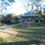


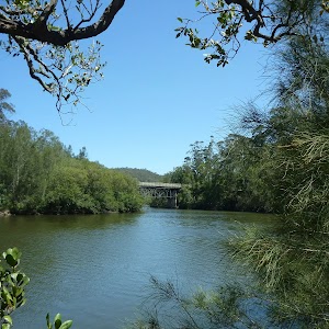
Girrakool Picnic Area
(0km) Girrakool picnic area car park → Int of Picnic Area and Girrakool Loop tracks

230 m
5 mins
0m
-27m
Easy track
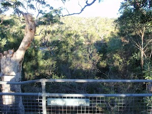
(0.23km) Int of Picnic Area and Girrakool Loop tracks → Broula Lookout
30 m
1 mins
0m
-2m
Easy track
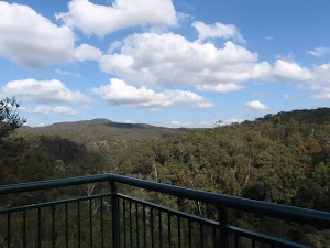
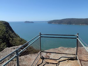
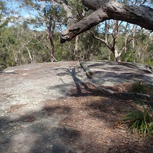
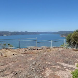
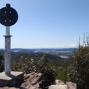
Broula Lookout
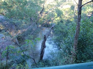
(0.23km) Int of Picnic Area and Girrakool Loop tracks → Illoura Lookout
40 m
1 mins
0m
-6m
Easy track
Illoura Lookout
(0.27km) Illoura Lookout → Int of Girrakool and Piles Ck lookout tracks
1.1 km
27 mins
47m
-83m
Moderate track
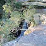
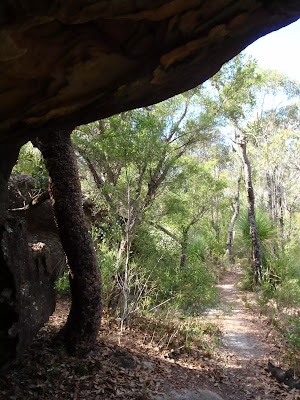
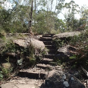
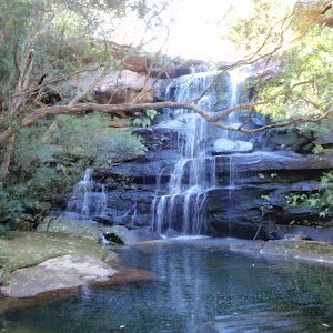
Veer left: From the top of Piles Creek waterfall, this walk follows the track heading south away from the waterfall (keeping the big valley to the right). The clear track winds through the thick bush crossing a few small tributaries and though four sandstone caves. The caves provide good shelter and a great spot to rest. The track then flattens out and comes to a 3-way intersection and a ‘Girrakool’ sign.
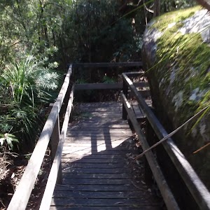
Continue straight: From the intersection, the walk heads south along the wide track in the opposite direction of the ‘Girrakool’ sign. Soon the track heads down a short wooden staircase to the intersection at the bottom (Piles Creek Lookout visible to the right).
(1.38km) Int of Girrakool and Piles Ck lookout tracks → Piles Ck Lookout
20 m
1 mins
0m
-8m
Moderate track
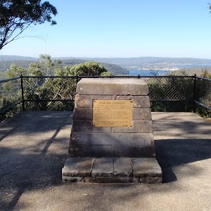
Piles Creek Lookout
(1.38km) Int of Girrakool and Piles Ck lookout tracks → Monolith Cave
80 m
2 mins
16m
0m
Moderate track
Monolith Cave
(1.46km) Monolith Cave → Rat Gully Lookout
220 m
7 mins
13m
-29m
Moderate track
(1.68km) Rat Gully Lookout → Scopas Peak
3.4 km
1 hr 26 mins
285m
-114m
Hard track
Turn sharp left: From the intersection, this walk follows the ‘Patonga Ferry’ sign[4] up the side of the gully, keeping the intermittent creek[5] to your left. The track leads past a ‘Patonga’ sign then winds steeply up the hill for about 130m, through a cleft in the rock[6] and past a few rock walls, and then the track mostly flattens out with some filtered distant views[7]. The track continues gently uphill for another 300m, becoming progressively flatter[8] before passing along the side of a long rock wall[9], with a tall sandstone overhang[10]. The track then crosses a small gully and leads past another overhang, where the track begins to lead downhill. The rocky track winds steeply downhill for about 130m to then cross an intermittent creek which flows over the solid sandstone platform[11].
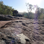
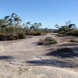
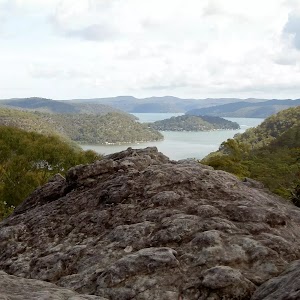
Continue straight: From the west side of the creek, this walk climbs uphill following the rocky track[12]. The track climb for about 600m, fairly steeply for a while then becoming progressively less steep[13]. The track passes a couple of rocky outcrops[14] to then come to a large flat rock platform, with distant views[15]. The rocky track then leads off this rock platform and continues up the ridge[16] for just shy of 300m to come to the edge of a much larger rock platform[17] with more views. A series of GNW arrow posts lead across this rock platform, generally leading towards Scopas Peak[18] for about 400m where the arrows lead off the rock platform and back onto a heathy track[19]. Keeping Scopas Peak up to the left, this track leads around the side of the hill for about 150m to pass a view across the valley to Mooney Mooney Bridge[20]. Over the next 800m, the track leads up across a few more rock platforms[21] then climbs fairly steeply up to a view point, just to the west of Scopas Peak[22].
(5.11km) Scopas Peak → Int of GNW and Wondabyne trail
2.3 km
45 mins
54m
-107m
Hard track
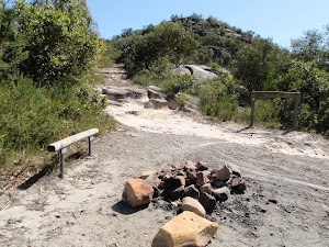
Continue straight: From the Great North Walk intentions book[30], after leaving your comments, this walk heads south, gently downhill[31] along the clear track. After about 150m, the walk comes to a T-intersection[32] with the Gosford Rifle Range trail – At this intersection is a ‘Girrakool’ sign[33], pointing back along the track.
Turn right: From the intersection, this walk follows the GNW arrow post[34] downhill along the management trail[35] (directly away from the ‘No Entry Past This Point’ sign[36]). The trail undulates moderately steeply in a few places) along the ridge line for about 900m, to then walk over a large rock platform[37]. From the top of this platform, there are some distant views over Mooney Mooney Creek[38]. On the large rock platform, this walk tends left to follow the scrape marks on the rock and soon find the wide trail again[39]. The trail leads downhill for about 50m, coming to a signposted intersection with a track on your left[40] and a ‘Girrakool’ sign[41] pointing back up the trail.
(7.4km) Int of GNW and Wondabyne Station Trail → Kariong Brook crossing
2 km
47 mins
64m
-211m
Hard track
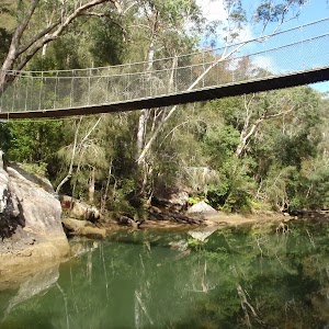
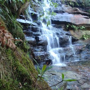
Continue straight: From the western side of Myron Brook, this walk crosses the creek on the sandstone rock platform[49] to follow the track up a few stone steps and up the short steep hill[50]. The track then flattens out as it leads around the side of the hill for about 200m to pass alongside a long rock wall[51] (on your left). Now leading downhill, the track continues for another 100m then heads down a short steep section[52] into the dense moist gully, coming to a faint intersection in front of Kariong Brook Falls[53] (on your left) (just before crossing the creek, which is often underground).
(9.36km) Kariong Brook crossing → Int of GNW and Thommos Loop track
2.2 km
52 mins
176m
-55m
Hard track
Veer right: From the intersection, this walk follows the GNW arrow post and ‘Patonga’ sign[66] downhill along the management trail[67]. The trail then winds along the side of the hill for about 1.3km (passing a pleasant grove of large Sydney Redgums[68]) to then step up onto a particularly large rock platform[69]. After crossing this rock platform, the trail continues for another 120m to come to a Y-intersection[70] (at another rock platform) where a ‘Girrakool’ sign[71] points back along the track.
(11.54km) Int of GNW and Thommos Loop trail → Int of GNW and Mt Wondabyne Peak tracks
2 km
43 mins
138m
-65m
Hard track
Turn right: From the intersection, the track follows the GNW arrow post along the management trail[81], initially keeping the power lines to your right. The trail soon bends left and leads uphill. As the trail flattens out again, it comes to a three-way intersection marked with a ‘Great North Walk’ and ‘Wondabyne Station’ sign[82], pointing back along the trail.
Turn left: From the intersection, this walk follows the ‘Mt Wondabyne’ sign[83] south up the trail. The trail soon begins to narrow[84] and after almost 200m, the track steps up to cross a rock platform[85], following a few GNW arrow posts to find a GNW ‘Walker Register’ tube[86]. After writing a comment, the walk continues uphill[87] along the track for about 700m, as the track become progressively flatter[88], passing beside the Mt Wondabyne Peak (up to your left). Then about 50m after leaving the trees and entering a section of low heath, this track then comes to a three-way intersection[89] (the Mt Wondabyne peak track, on the left[90]), marked with a GNW arrow post.
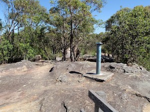
(13.53km) Int of Great North Walk and Mt Wondabyne Peak tracks → Mt Wondabyne Peak
210 m
5 mins
20m
-1m
Hard track
Mt Wondabyne

(13.53km) Int of Great North Walk and Mt Wondabyne Peak tracks → Mt Wondabyne Campsite
90 m
2 mins
0m
-6m
Moderate track
Mt Wondabyne Campsite
End of day 1
(13.62km) Mt Wondabyne Campsite → Int of Tunnel Track and Mt Wondabyne trail
760 m
16 mins
0m
-49m
Moderate track
(14.37km) Int of Tunnel Track and Mt Wondabyne trail → Woy Woy landfill view
2.5 km
51 mins
83m
-98m
Hard track
Continue straight: From the intersection, this walk follows the ‘Patonga’ sign[110] south, downhill along the wide trail. After just over 100m, the trail passes through a metal gate[111] and fence then continues for another 50m to come to an intersection with a narrow track[112] (on your left), marked with a GNW arrow post and ‘Tunnel Trail’[113] (on your right).
Turn left: From the intersection, this walk follows the GNW arrow post directly away from the face of the ‘Tunnel Trail’ sign[114][115] along the narrow track. After about 20m, this short track leads to an intersection with the signposted ‘Dillons Trail’[116].
Continue straight: From the intersection, this walk follows the GNW arrow post and ‘Patonga’ sign[117] south-west up along the narrow track[118]. The track leads fairly gently uphill for about 300m, then mostly flattens out along the side of a rock platform[119] for another 500m to come to a high point[120]. The track now undulates, following a series of many GNW arrow posts[121] generally down along the rocky ridge line, over many rock platforms[122] for almost 1km (enjoying the distant views[123][124] over Woy Woy Bay and the Brisbane Water, to your left). The walk then steps down off the rock platform[125] via a few carved steps[126] onto a sandy track. This track then leads gently down for about 130m, coming to an unfenced, clear view over Woy Woy landfill[127] (where the track then bends right[128]).
(16.85km) Woy Woy landfill view → Rock Platform
960 m
25 mins
39m
-77m
Hard track
Turn right: From the intersection, this walk follows the GNW arrow post uphill along the wide trail. The trail leads uphill for about 200m to then lead quite steeply downhill[139] for another 200m. Here the trail winds through a ferny valley[140] with a scattering of cabbage palms[141] (Livistona australis) then uphill for about 80m, where the trail bends right and leads down a short distance to find a noteable rock platform[142] (with an ephemeral creek) and filtered view down the valley (to your right)[143].
(17.82km) Rock Platform → Int of Hawkesbury track and Sani Depot Trail
1.3 km
25 mins
56m
-21m
Moderate track
Continue straight: From the intersection, this walk follows the wide management trail (the Hawkesbury Track) gently uphill, initially keeping the wide valley to your right. The trail leads through the open heath for about 170m to enter a more wooded forest and cross a culverted creek[147] (with sandstone blocks[148]). Here the trail begins to climb, becoming progressively steeper for about 600m before entering a tall Sydney Redgum forest and flattening out a clear three-way intersection, marked with a ‘Sani Depot Trail’ sign[149] (on your left).
(19.15km) Int of Hawkesbury track and Sani Depot Trail → Int of Hawkesbury track and Patonga Dr trail
1.1 km
21 mins
39m
-25m
Moderate track
(20.26km) Rock platform intersection → Int of Rest Area and Girrakool tracks
750 m
12 mins
12m
-5m
Moderate track
Turn right: From the intersection, this walk follows the ‘Patonga’ sign[161] south gently up along the sandy management trail. The trail leads among the heath and large scribbly gums[162] for about 270m to come to a T-intersection[163], marked with a GNW arrow post[164] (where the main trail bends left and the old Patonga Creek trail is on the right).
Turn left : From the intersection, this walk follows the GNW arrow post east, gently up along the wide management trail. After about 100m, the trail bends right[165], then continues mostly flat for nearly 200m, coming to a clear three-way intersection[166] where a ‘Girrakool’ sign[167] points back up along the trail.
(21.01km) Int of Rest Area and Girrakool tracks → Warrah Car Park
1.6 km
29 mins
22m
-25m
Moderate track
Continue straight: From the intersection and locked gate[172], this walk crosses the sealed Patonga Drive[173] to find a GNW arrow post and track on the other side. This walk now follows the GNW arrow post along the track, as it bends right to lead parallel to Patonga Drive (keeping the road about 20m to your right) for about 150m before passing some distant ocean views[174] (on your left). Here the track continues for another 100m to pass a drainage ditch[175] and come to a T-intersection[176] with the dirt Warrah Trig Station Rd.
Veer left: From the intersection near Patonga Drive, this walk follows the dirt road away from Patonga Drive. After a little while the road heads down a gentle hill then comes to an intersection with a management trail and locked gate (on the right).
Continue straight: From the intersection, this walk follows the dirt road south east towards the hill and fence. Soon the road passes a trail (on the left) and then heads through a dirt over flow car park, to come to a smaller sealed car park at the end of the road.
(22.66km) Warrah car park → Warrah Trig Station
30 m
1 mins
0m
0m
Easy track
Warrah Trig Station
(22.69km) Warrah Trig Station → Warrah Lookout intersection
310 m
7 mins
0m
-39m
Easy track
(23km) Warrah Lookout intersection → Warrah Lookout
70 m
2 mins
0m
-12m
Easy track
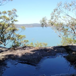
Warrah Lookout
(23km) Warrah Lookout intersection → Broken Bay View
700 m
15 mins
26m
-26m
Moderate track
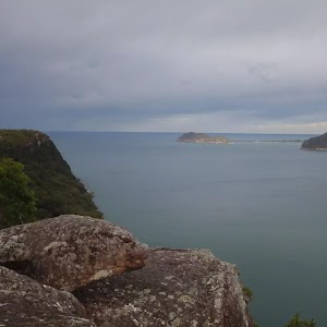
Veer left: From the intersection, this walk follows the Great North Walk arrow and ‘Patonga’ sign[183] along the narrow track. The track winds gently through the bush, with the occasional water glimpse to the left. After a short time, the track leads to a few large Sydney Red Gums and a large unfenced rock platform on the left (just before a few Great North Walk arrow markers) – this is the Broken Bay view.
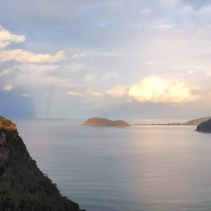
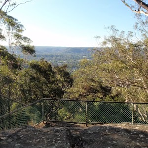
Broken Bay View

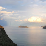
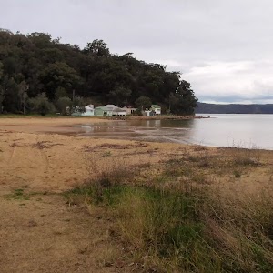
(23.7km) Broken Bay View → Patonga Wharf car park
1.1 km
31 mins
13m
-136m
Moderate track
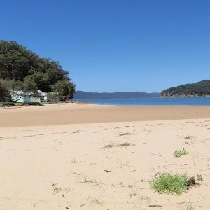
Continue straight: From the eastern end of the beach, this walk follows the power lines across the sand, keeping the water to the left. The walk soon heads around the gate, across the car park and comes to the Warrah Reserve boat ramp.
Continue straight: From the boat ramp, this walk follows the road[186], keeping the water to the left for 220m to then turn left, following a GNW arrow post[187], down along Patonga Drive. The walk then soon leads past a ‘The Great North Walk’ sign[188] opposite the toilet block[189] and continues down past ‘Eve Williams Memorial Oval’[190][191][192] for 70m to a car park at Patonga Wharf[193], opposite some shops[194]. (Alternatively it is possible to walk along the sandy beach[195] from the Boat ramp to the wharf.)
Maps for the Girrakool to Patonga Overnight walk
You can download the PDF for this walk to print a map.These maps below cover the walk and the wider area around the walk, they are worth carrying for safety reasons.
| Gunderman | 1:25 000 Map Series | 91313S GUNDERMAN | NSW-91313S |
| Gosford | 1:25 000 Map Series | 91312S GOSFORD | NSW-91312S |
| Broken Bay | 1:25 000 Map Series | 91301N BROKEN BAY | NSW-91301N |
| Ku-ring-gai Chase National Park Tourist Map | 1:40 000 Map Series | CMA Ku-ring-gai Chase National Park Tourist Map | CMA Ku-ring-gai Chase National Park Tourist Map |
| Gosford | 1:100 000 Map Series | 9131 GOSFORD | 9131 |
| Sydney | 1:100 000 Map Series | 9130 SYDNEY | 9130 |
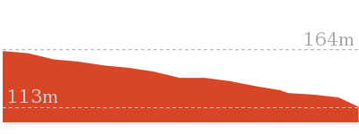
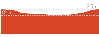
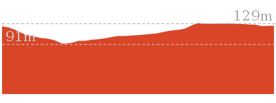
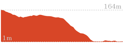
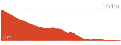
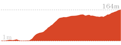
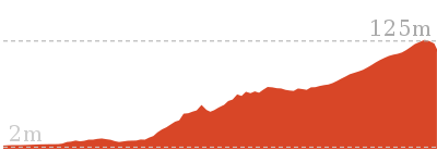
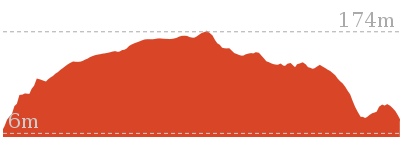
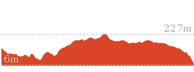
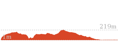
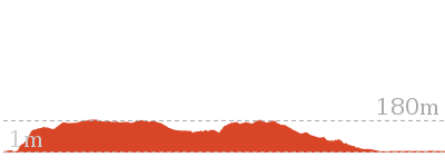
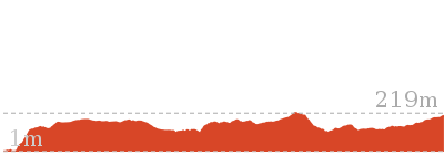
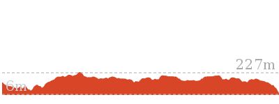
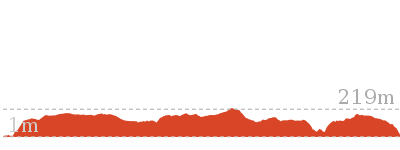
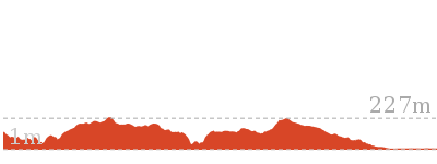
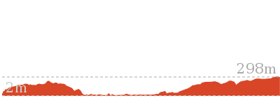
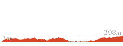
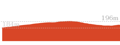
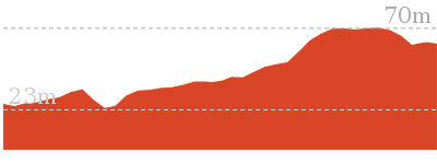
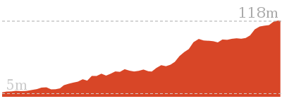
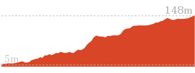
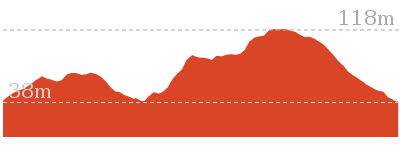
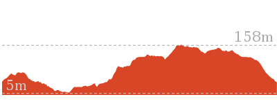
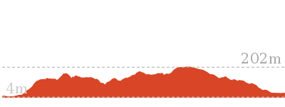
Cross sectional view of the Girrakool to Patonga Overnight bushwalking track
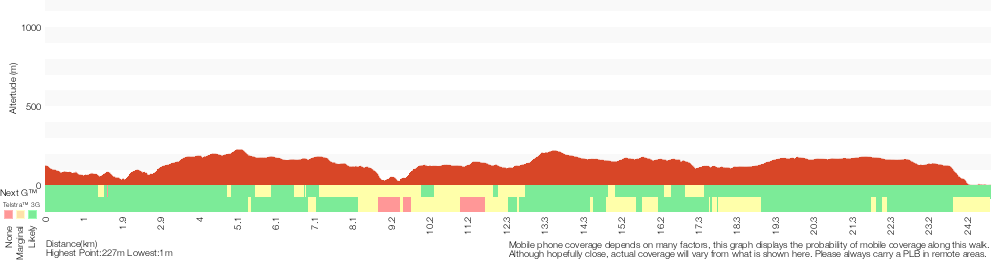
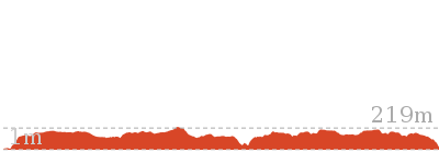
Analysis and summary of the altitude variation on the Girrakool to Patonga Overnight
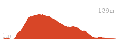
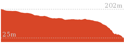
Daily actual walking time estimates
| Day | Walking Time | Length |
|---|---|---|
| 1 | 5 hrs 24 mins | 13.9 km |
| 2 | 3 hrs 55 mins | 11.3 km |
Overview of this walks grade – based on the AS 2156.1 – 2001
Under this standard, a walk is graded based on the most difficult section of the walk.
| Length | 24.8 km | ||
| Time | 2 Days | ||
| . | |||
| Grade 4/6 Hard track |
AS 2156.1 | Gradient | Very steep (4/6) |
| Quality of track | Rough track, where fallen trees and other obstacles are likely (4/6) | ||
| Signs | Minimal directional signs (4/6) | ||
| Experience Required | Some bushwalking experience recommended (3/6) | ||
| Weather | Storms may impact on navigation and safety (3/6) | ||
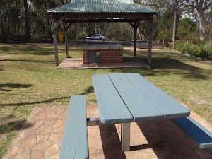
| Infrastructure | Limited facilities (such as cliffs not fenced, significant creeks not bridged) (4/6) |
Some more details of this walks Grading
Here is a bit more details explaining grading looking at sections of the walk
Gradient
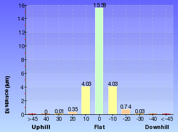
9km of this walk has gentle hills with occasional steps and another 8km has short steep hills. Whilst another 7km is very steep and the remaining 1.4km is flat with no steps.
Quality of track
13km of this walk follows a clear and well formed track or trail and another 8km follows a rough track, where fallen trees and other obstacles are likely. The remaining (3.8km) follows a formed track, with some branches and other obstacles.
Signs
16km of this walk has directional signs at most intersection and another 5km is clearly signposted. The remaining (3.5km) has minimal directional signs.
Experience Required
Around 13km of this walk requires no previous bushwalking experience, whilst the remaining 12km requires some bushwalking experience.
weather
Around 23km of this walk is not usually affected by severe weather events (that would unexpectedly impact safety and navigation), whilst the remaining 1.7km is affected by storms that may impact your navigation and safety.
Infrastructure
16km of this walk is close to useful facilities (such as fenced cliffs and seats) and another 9km has limited facilities (such as not all cliffs fenced). The remaining (440m) has limited facilities (such as cliffs not fenced, significant creeks not bridged).
Similar walks
756 m Return
20 mins
Easy track
803 m Circuit
20 mins
Moderate track
1.1 km Circuit
30 mins
Moderate track
1.4 km Circuit
45 mins
Moderate track

2.2 km One way
1 Hr
Moderate track
2.8 km One way
1 hr 15 mins
Moderate track
4.2 km Circuit
2 hrs
Moderate track

4.3 km Return
2 hrs
Moderate track
4.3 km One way
1 hr 45 mins
Moderate track
5.1 km Return
2 hrs
Moderate track
5.8 km Return
2 hrs 30 mins
Hard track
8.1 km Return
3 hrs 30 mins
Hard track
9.5 km One way
4 hrs
Hard track
10.1 km One way
4 hrs 15 mins
Hard track

10.8 km Circuit
4 hrs 30 mins
Hard track

12.3 km One way
5 hrs 30 mins
Hard track

15.4 km One way
6 hrs
Hard track
15.5 km One way
5 hrs 45 mins
Hard track
16.1 km One way
6 hrs 30 mins
Experienced only

17 km One way
6 hrs 30 mins
Hard track
18.1 km One way
7 hrs 30 mins
Experienced only
19.5 km One way
7 hrs 30 mins
Hard track
20 km Circuit
7 hrs 30 mins
Moderate track

20.7 km One way
8 hrs 30 mins
Hard track
24 km One way
8 hrs 30 mins
Experienced only

24.8 km One way
10 hrs
Hard track

26.2 km One way
10 hrs
Hard track
26.2 km One way
2 Days
Hard track

28.1 km One way
2 Days
Experienced only
33.4 km One way
2 Days
Hard track

41.5 km One way
3 Days
Hard track
Other Nearby walks
378 m Return
10 mins
Easy track

16.1 km One way
6 hrs
Hard track

800 m Return
20 mins
Very easy
426 m Return
20 mins
Moderate track

991 m One way
30 mins
Moderate track
1.7 km Circuit
45 mins
Moderate track


3 km Return
1 hr 30 mins
Hard track
2.2 km One way
1 Hr
Hard track
3 km One way
1 hr 30 mins
Hard track

2.1 km Circuit
1 hr 15 mins
Hard track

6.1 km Circuit
2 hrs 45 mins
Hard track
11.3 km One way
4 hrs 30 mins
Hard track
Plan your trip to and from the walk here
The Girrakool to Patonga Overnight walk starts at the Girrakool picnic area car park (gps: -33.43168, 151.2766)Your main transport option to Girrakool picnic area car park is by;
(get details)
The Girrakool to Patonga Overnight ends at the Patonga Wharf car park (gps: -33.55043, 151.27456)
Your transport options to Patonga Wharf car park are by;
(get details)


Short URL = http://wild.tl/gtpxx
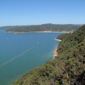
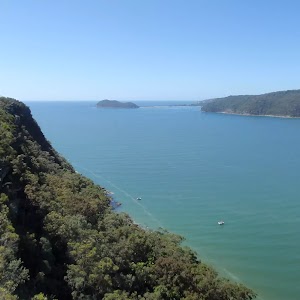
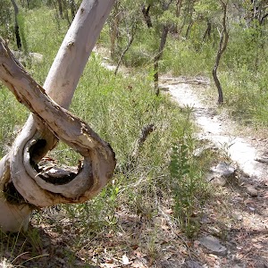
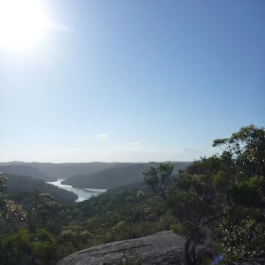
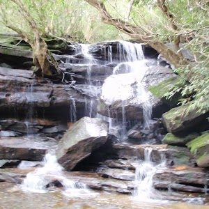
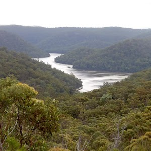
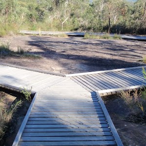
Gallery images
There are other downloads I am still working on.
You will probably need to login to access these — still all free.
* KML (google earth file)
* GPX (GPS file)
Special Maps/ brochures
* A3 topo maps
* PDF with Lands Topo map base
* PDF with arial image (and map overlay)
I wanted to get the main site live first, this extra stuff will come in time.
Happy walking
Matt 🙂
Comments