The Oaks Picnic area to Woodford Station


The Oaks Picnic Area
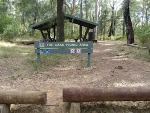
(0km) The Oaks Picnic Area → Int. Wheel Gully Trail and Oaks Firetrail
Veer left: From the intersection, the walk heads past the Red Hand Cave intersection and west along the management trail, with the picnic area on the right and car park to the left. The walk heads down the road for a very short time, to the signposted intersection.
Continue straight: From the intersection, the walk does not head in the direction of 'Nepean lookout' but leads to the gate and fence up the other trail.
Continue straight: From the intersection, the walk heads up the slight hill, passing the gate. The trail winds slowly as it climbs the gentle slope for quite some time. The trail then flattens out and leads to a steeper gradient, and at the top, comes to a '15km to Woodford' sign.
Continue straight: From the sign, the walk continues upwards along the trail, winding slowly for some kilometres. The vegetation either side of the trail stays relatively the same, passing some clearings with demolished trees in them. As the trail begins to head north, it continues to wind uphill, passing a large clearing on the left. Soon after the large clearing, the walk comes to an intersection on the right, before the track turns left sharply.
(6km) Int. Wheel Gully Trail and Oaks Firetrail → Int. in Wheel Gully loop
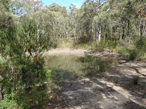
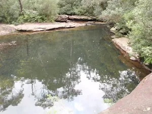
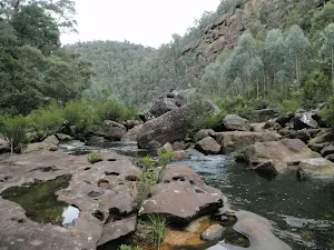
Continue straight: From the intersection the track heads down the left or right track to wind around and down to a dam. From the dam the track winds back up either track to the intersection. At the end of this side trip, retrace your steps back to the main walk then Turn right.
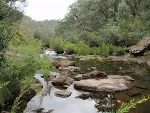
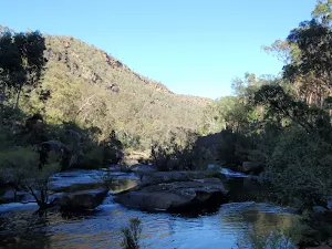
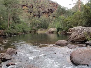
Wheel Gully
(6km) Int. Wheel Gully Trail and Oaks Firetrail → Int. Oaks Firetrail and cliff lookout Trk
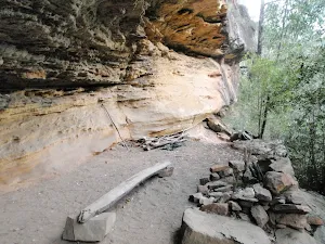
Continue straight: From the intersection, the walk heads up the hill to the north, winding steeply up past a rock shelf with a view (on the left). The track continues steeply uphill, then winds across a plateau with rocky surfaces to both sides of the track. The vegetation here is also lower and sparser, giving views of the surrounding valleys. The track winds across this plateau and hillsides for some time before descending steeply, passing a blue marker sign on the right before coming to the intersection with St Helena Ridge Trail.
Continue straight: From the intersection, the walk heads down across the saddle and tends right below the cliff (above on the left). The trail winds up and onto a plateau lined with rocks, which look as though they could have been placed there. The vegetation along this higher area is lower and clearer, which gives views across the distant ridge lines. The walk continues to head in a northerly direction and descends right, off the plateau, to head up another hill to a stepped intersection on the left.
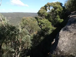
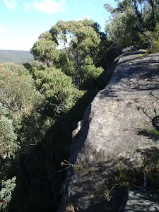
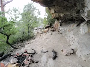
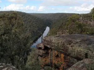
(14km) Int. Oaks Firetrail and cliff lookout Trk → Cliff lookout
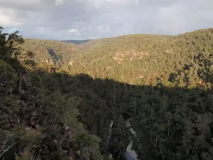
Cliff Lookout
(14km) Int. Oaks Firetrail and cliff lookout Trk → Int. Oaks Firetrail and Old Bathurst Rd
(17km) Int. Oaks Firetrail and Old Bathurst Rd → Woodford Station
Maps for the The Oaks Picnic area to Woodford Station walk
You can download the PDF for this walk to print a map.
These maps below cover the walk and the wider area around the walk, they are worth carrying for safety reasons.
| Springwood | 1:25 000 Map Series | 90304S SPRINGWOOD | NSW-90304S |
| Penrith | 1:25 000 Map Series | 90303N PENRITH | NSW-90303N |
| Jamison | 1:25 000 Map Series | 89302N JAMISON | NSW-89302N |
| Katoomba | 1:25 000 Map Series | 89301S KATOOMBA | NSW-89301S |
| Penrith | 1:100 000 Map Series | 9030 PENRITH | 9030 |
| Katoomba | 1:100 000 Map Series | 8930 KATOOMBA | 8930 |
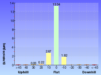
Cross sectional view of the The Oaks Picnic area to Woodford Station bushwalking track
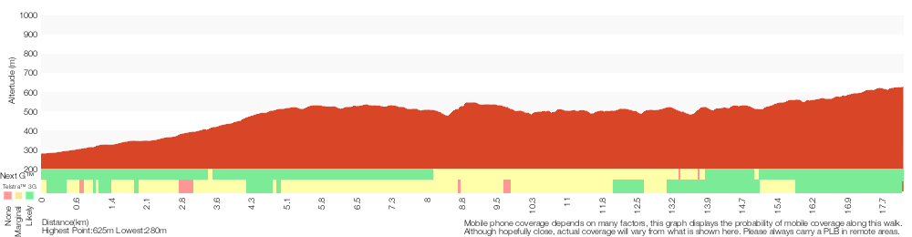
Analysis and summary of the altitude variation on the The Oaks Picnic area to Woodford Station
Overview of this walks grade – based on the AS 2156.1 – 2001
Under this standard, a walk is graded based on the most difficult section of the walk.
| Length | 18.1 km | ||
| Time | 7 hrs | ||
| . | |||
Grade 4/6 Hard track | AS 2156.1 | Gradient | Very steep (4/6) |
| Quality of track | Formed track, with some branches and other obstacles (3/6) | ||
| Signs | Minimal directional signs (4/6) | ||
| Experience Required | No experience required (1/6) | ||
| Weather | Weather generally has little impact on safety (1/6) | ||
| Infrastructure | Limited facilities, not all cliffs are fenced (3/6) |
Some more details of this walks Grading
Here is a bit more details explaining grading looking at sections of the walk
Gradient
11km of this walk has short steep hills and another 4km is very steep. Whilst another 3.1km has gentle hills with occasional steps and the remaining 270m is flat with no steps.
Quality of track
12km of this walk follows a formed track, with some branches and other obstacles and another 6km follows a clear and well formed track or trail. The remaining (730m) follows a smooth and hardened path.
Signs
13km of this walk has directional signs at most intersection and another 4km has minimal directional signs. The remaining (930m) is clearly signposted.
Experience Required
This whole walk, 18km requires no previous bushwalking experience.
weather
This whole walk, 18km is not usually affected by severe weather events (that would unexpectedly impact safety and navigation).
Infrastructure
Around 17km of this walk has limited facilities (such as not all cliffs fenced), whilst the remaining 730m is close to useful facilities (such as fenced cliffs and seats).
Similar walks
A list of walks that share part of the track with the The Oaks Picnic area to Woodford Station walk.
Woodford Station to cliff lookout
8.6 km Return, 3 hrs 30 mins
Hard track
Martin's Lookout to Woodford Station
15.9 km One way, 7 hrs
Experienced only
Woodford to Blaxland Station
18.3 km One way, 7 hrs 15 mins
Experienced only
Woodford to Faulconbridge
23.4 km One way, 2 Days
Experienced only
Woodford to Glenbrook
29.6 km One way, 3 Days
Hard track
Other Nearby walks
A list of walks that start near the The Oaks Picnic area to Woodford Station walk.
Attic Cave
2 km Return, 1 Hr
Experienced only
Dadder Cave
6 km Return, 4 hrs
Very experienced only
Dadder Cave and Jack Evans track
10.3 km Circuit, 2 Days
Very experienced only
Erskine Creek via Pisgah Rock
2.8 km Return, 3 hrs
Very experienced only
Erskine Creek via Pisgah Rock and Jack Evans
7.1 km Circuit, 4 hrs 30 mins
Very experienced only
Pisgah Rock
1.6 km Return, 45 mins

Moderate track
Machins Crater
466 m Return, 15 mins
Moderate track
Erskine Lookout
648 m Return, 20 mins
Moderate track
Jack Evans track to Erskine Creek
2.6 km Return, 2 hrs
Experienced only
Nepean Lookout
1.3 km Return, 30 mins
Moderate track
Euroka to Red Hands Cave
4.3 km One way, 1 hr 45 mins
Experienced only
Euroka Nepean River Circuit
2.8 km Circuit, 1 hr 15 mins
Hard track
Plan your trip to and from the walk here
The The Oaks Picnic area to Woodford Station walk starts at the The Oaks Picnic Area (gps: -33.811583, 150.56521)
The The Oaks Picnic area to Woodford Station ends at the Woodford Station (gps: -33.735763, 150.48228)
Weather Forecast
This walk starts in the Central Tablelands weather district.
Current Alerts
Park Information
Blue Mountains National Park
Attracting over 3 million visitors annually, Blue Mountains National Park holds some of Australia's most spectacular and diverse wilderness areas. Explore the Grose Valley, with its sheer sandstone cliffs, waterfalls and scenic walking, or enjoy the famous views of the Three Sisters. Easy access makes a day trips very worthwhile, but with such diversity it would be great to stay in one of the many B&B's and spend a few days soaking up the region.
Comments
Short URL: http://wild.tl/topatws