North Arm Walking Track
(0km) H.C. Press Park → End of Willis Rd
(1km) End of Willis Rd → Mannerim Rd turnoff
(2km) Mannerim Rd turnoff → Pump Station Int
Continue straight: From the intersection, this walk heads down the road to the south, coming to a small intersection with a diverging track, marked by an arrow. At this point, there is a large fenced building, approximately 100m away.
(2km) Pump Station Int → North Arm Road
Maps for the North Arm Walking Track walk
You can download the PDF for this walk to print a map.
These maps below cover the walk and the wider area around the walk, they are worth carrying for safety reasons.
| Parramatta River | 1:25 000 Map Series | 91303N PARRAMATTA RIVER | NSW-91303N |
| Sydney | 1:100 000 Map Series | 9130 SYDNEY | 9130 |
Cross sectional view of the North Arm Walking Track bushwalking track
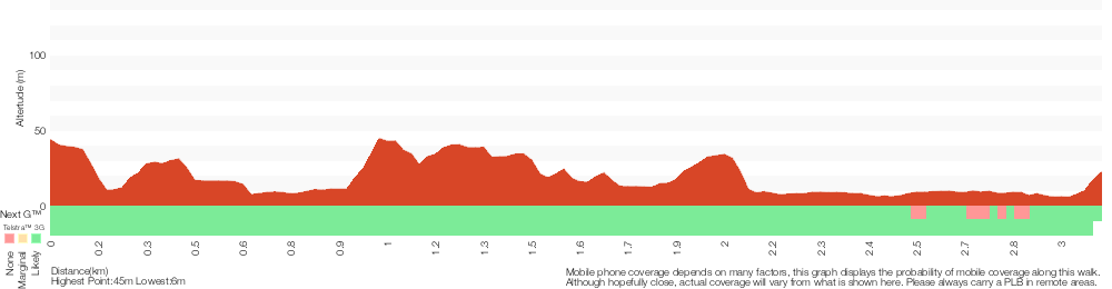
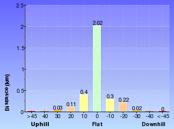
Analysis and summary of the altitude variation on the North Arm Walking Track
Overview of this walks grade – based on the AS 2156.1 – 2001
Under this standard, a walk is graded based on the most difficult section of the walk.
| Length | 3.1 km | ||
| Time | 2 hrs | ||
| . | |||
Grade 3/6 Moderate track | AS 2156.1 | Gradient | Short steep hills (3/6) |
| Quality of track | Clear and well formed track or trail (2/6) | ||
| Signs | Directional signs along the way (3/6) | ||
| Experience Required | Some bushwalking experience recommended (3/6) | ||
| Weather | Weather generally has little impact on safety (1/6) | ||
| Infrastructure | Limited facilities, not all cliffs are fenced (3/6) |
Some more details of this walks Grading
Here is a bit more details explaining grading looking at sections of the walk
Gradient
This whole walk, 3.1km has short steep hills.
Quality of track
This whole walk, 3.1km follows a clear and well formed track or trail.
Signs
Around 2.4km of this walk is clearly signposted, whilst the remaining 740m has directional signs at most intersection.
Experience Required
This whole walk, 3.1km requires some bushwalking experience.
weather
This whole walk, 3.1km is not usually affected by severe weather events (that would unexpectedly impact safety and navigation).
Infrastructure
This whole walk, 3.1km has limited facilities (such as not all cliffs fenced).
Other Nearby walks
A list of walks that start near the North Arm Walking Track walk.
Flat Rock Beach track
516 m Return, 20 mins

Moderate track
Engravings Track
2.2 km One way, 45 mins

Moderate track
Seaforth Oval to Davidson Park
10 km One way, 4 hrs 30 mins

Hard track
Seaforth Oval to Roseville Bridge via Bantry Bay
10 km One way, 4 hrs
Hard track
Seaforth Oval to the Bluff Lookout
5.4 km Return, 3 hrs
Hard track
Timber Getters Track
1.8 km Return, 1 Hr
Hard track
Spit Bridge to Manly (Manly Scenic Walkway)
9.1 km One way, 3 hrs 45 mins
Moderate track
Spit Bridge to North Harbour Reserve
8.7 km Circuit, 4 hrs
Moderate track
Manly Dam Circuit Walk
7.3 km Circuit, 3 hrs

Moderate track
Manly Dam Nature Trail
3.2 km Return, 1 hr 30 mins

Moderate track
Spit Bridge to Middle Head Forts
6.1 km One way, 2 hrs 30 mins
Hard track
Spit to Lindfield
22.6 km One way, 9 hrs 45 mins
Hard track
Plan your trip to and from the walk here
The North Arm Walking Track walk starts at the H.C. Press Park (gps: -33.789673, 151.22865)
The North Arm Walking Track ends at the North Arm Road (gps: -33.792453, 151.21522)
Weather Forecast
This walk starts in the Metropolitan weather district.
Current Alerts
Park Information
Comments
Short URL: http://wild.tl/nawt