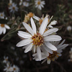
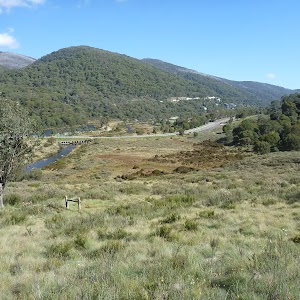
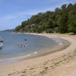
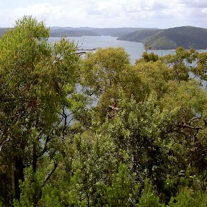
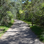
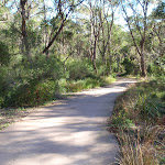
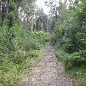
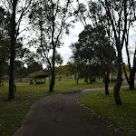
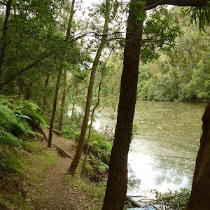
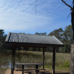
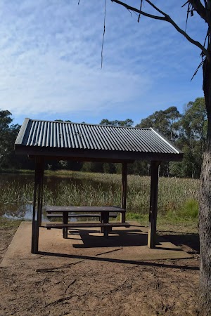
This walk starts with a ride up the Kosciuszko Express Chairlift. There is an opportunity to eat at Australia’s highest restaurant, before heading over the Rams Head Range. After enjoying the spectacular views from the Rams Head Range, the walk drops to Dead Horse Gap, then follows a bush track along the Thredbo river. After passing the golf course, the walk returns to the base of the chairlift. Alternatively, you may organise a lift from Dead Horse Gap.
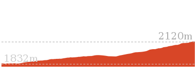
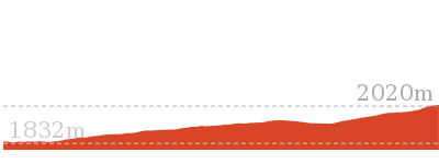
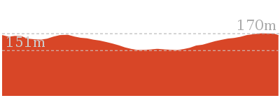
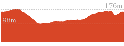
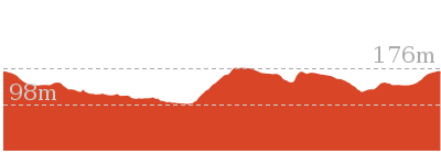
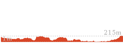
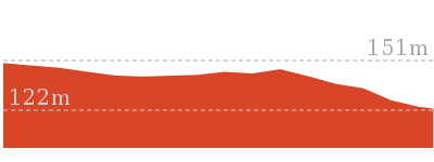
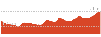
Dead Horse Gap Loop track
And Walk
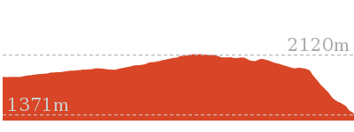
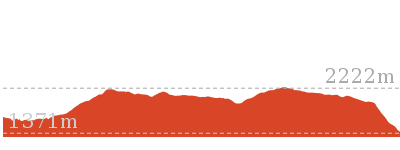
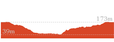
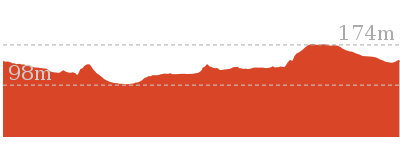
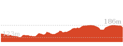
Dead Horse Gap Loop track


4 hrs 30 mins
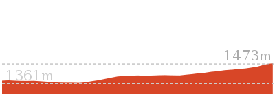
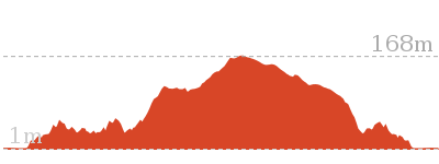
9.8 km Circuit

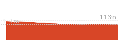
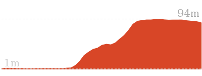
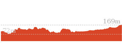
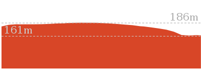
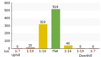
144 m
Hard track


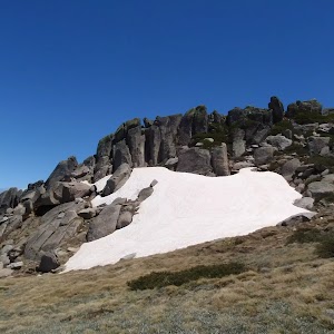
Covered in snow part of the year
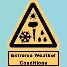
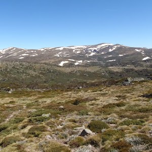
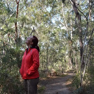
This walk leads through an extreme alpine environment and all walkers must be well prepared. During summer, be prepared for both very hot and cold weather, high winds, rain, snow, extreme UV levels and some sections of snow or ice on the ground. Before starting this walk, check advice with Snowy Region Visitor Information Centre (02) 6450 5600, the weather forecast and the snow conditions then change your plans as needed. These notes, grades and walking times have been written for use in the summer months only. Between May and the end of October, this walk is likely to be covered in snow/ice, visitors should be carrying and be prepared to use snowshoes or cross country skis. When there is a chance of significant snow on the ground, visitors will need particularly strong navigation and snowcraft skills – tracks and signage may not be visible. For most visitors, it is best to consider this walk closed during the colder months.
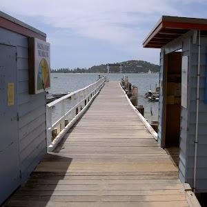
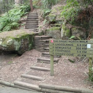
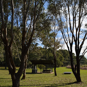
Kosciuszko Express Chairlift
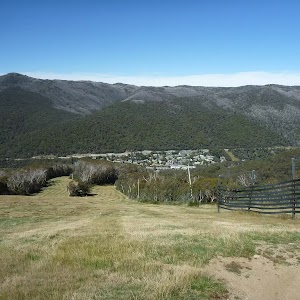
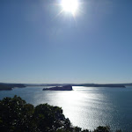
This is one of the few lifts operating in the summer months at Thredbo, and is made quite popular by thousands of people walking to the summit of Mt Kosciuszko each year. Lift tickets can be purchased from the store at the bottom of the chairlift. Lift tickets are $31 return ($25 one way) per person. This lift is generally closed during November and May for maintenance each year, but the the Snowgum chair can be used at this time instead, this will add extra walking time to you walk. More info.
(0km) Bottom of Kosciuszko Express chairlift → Top of Kosciuszko Express chairlift

1.9 km
20 mins
558m
-1m
Very easy
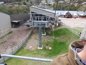
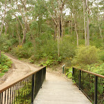
This walk heads into the ‘Valley Terminal’ building, where you can buy a ticket for the lift. Continue through the building and up the steps, where this walk turns right to find the bottom terminal of the ‘Kosciuszko Express’. Walk up to the platform as directed by the chairlift operator and sit down in the seat, letting it scoop you up. Once seated, pull down the safety bar and enjoy the ride to the top of the ridge. 🙂
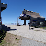
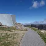
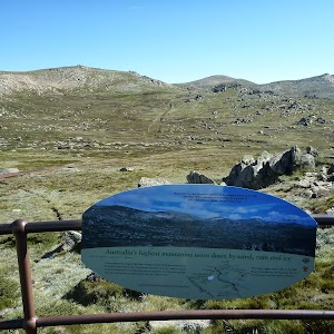
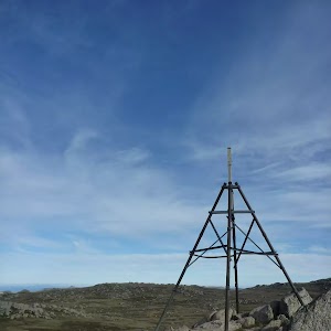
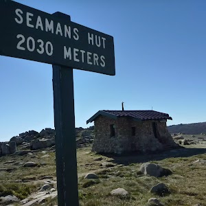
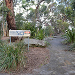
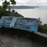
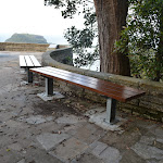
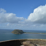
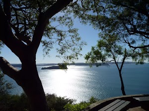
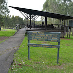
At the top step of the chair lift and turn left to find the restaurant (now on your right) and track information signs ahead.
At the top step of the chair lift and turn left to find the restaurant (now on your right) and track information signs ahead.
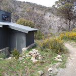
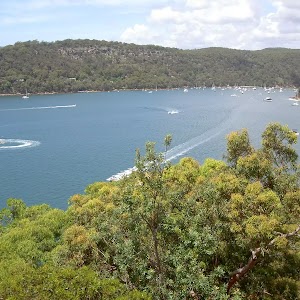
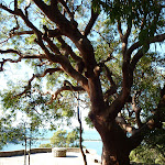
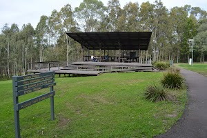
Eagles Nest Restaurant

This is Australia’s highest restaurant, providing great food and outstanding views. It is easily accessible, nestled on the mountain directly opposite the top of the Kosciuszko Express chairlift, and is open year-round. For more information, call (02) 64576019.
(1.86km) Top of Kosciuszko Express chairlift → Int of Dead Horse Gap track and Kosciuszko footpath
350 m
6 mins
23m
0m
Moderate track
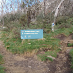
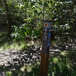
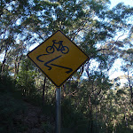
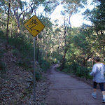
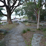
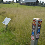
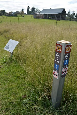
Turn right: From the top of the chairlift[3], this walk follows the footpath around Eagles Nest restaurant[4][5] (keeping the building to your right). The walk passes the large map[6] and information signs[7], heading up the gentle hill along the paved path[8]. Near the top of the rise, the path leads to a signposted intersection with the ‘Dead Horse Gap’ track[9] (on your left), where there is also an arrow pointing back to ‘Eagles Nest Restaurant’[10].
(2.21km) Int of Dead Horse Gap track and Kosciuszko footpath → Top of Basin Tbar
110 m
2 mins
10m
-1m
Hard track
Veer left: From the intersection, the track follows the rocky bush track a short distance to the top of the Basin Tbar.
(2.32km) Top of Basin Tbar → Upper rest area
1.7 km
36 mins
54m
-74m
Hard track
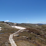
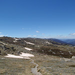
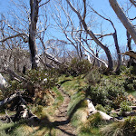
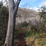
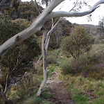
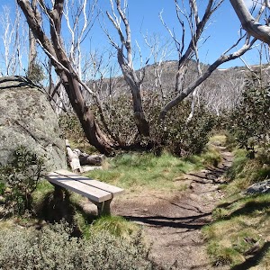
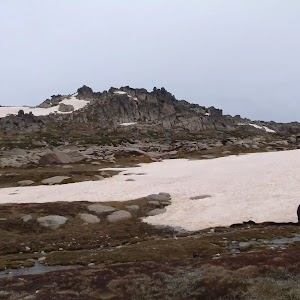
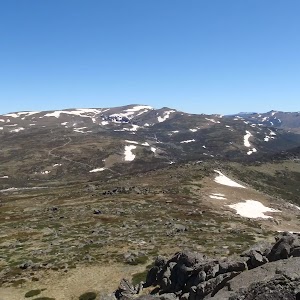
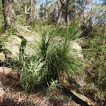
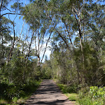
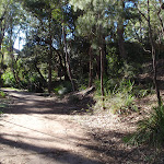
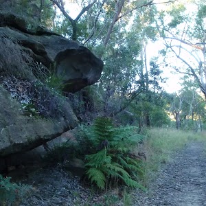
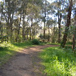
Continue straight: From the top of the Tbar, the walk follows the bush track heading west along the ridgeline. The track climbs the hill, passing numerous rock outcrops, and reaches an information sign titled “above the tree line”.
Continue straight: From the signpost, the walk follows the bush track along the ridgeline, down the hill. The track passes a long line of ski run markers, continuing down towards the tree line until it comes to the intersection at the wooden bench.
Continue straight: From the signpost, the walk follows the bush track along the ridgeline, down the hill. The track passes a long line of ski run markers, continuing down towards the tree line until it comes to the intersection at the wooden bench.
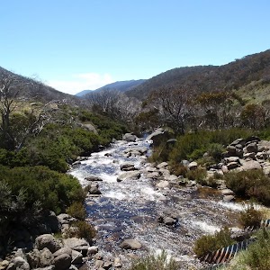
(3.99km) Upper rest area → Int of Thredbo River and Dead Horse Gap tracks
3 km
1 hr 27 mins
11m
-405m
Moderate track
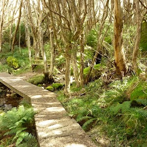
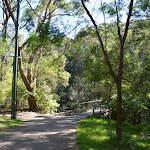
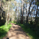
Continue straight: From the intersection, the walk follows the bush track down the hill. The track winds down the long hill, crossing some metal walkways and wooden boardwalks, then passing through the snowgum forest until it comes to the second, small rest area at the wooden bench seat.
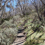
Continue straight: From the bench, the walk follows the bush track down the rocky hill. The track passes through the open snow gum forest, down into the valley. The track goes down a long set of wooden steps and comes to an intersection signposted ‘Dead Horse Gap track’.
Continue straight: From the bench, the walk follows the bush track down the rocky hill. The track passes through the open snow gum forest, down into the valley. The track goes down a long set of wooden steps and comes to an intersection signposted ‘Dead Horse Gap track’.
(7.02km) Int of Thredbo River and Dead Horse Gap tracks → Cascades Trail track head
160 m
3 mins
3m
-6m
Moderate track
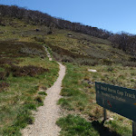
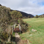
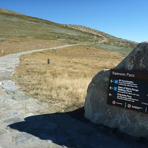
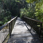
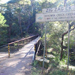
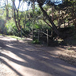
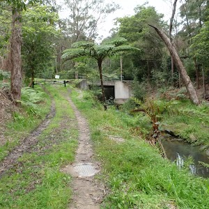
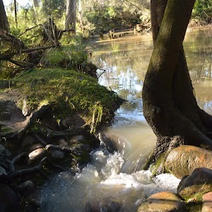
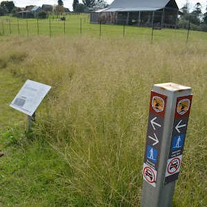
Turn right: From the intersection, this walk follow the clear track away from the other two sign posted tracks to soon cross Bogong Creek[11] on a metal bridge[12]. The track then leads left and heads up a series of steps to follow behind the road barrier, soon coming to a ‘Thredbo Walking Tracks’ sign[13] beside the road. Here the walk crosses the road to find the Cascades Trail track head car park (on the Alpine Way 5.4km west of Friday Drive).
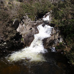
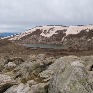
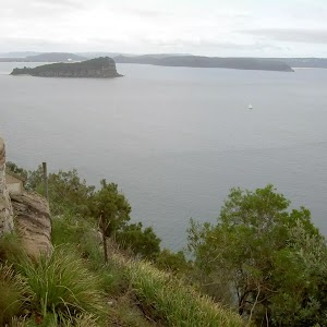
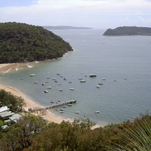
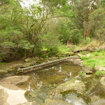
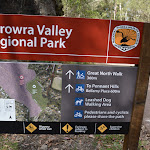
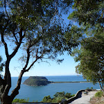
Dead Horse Gap
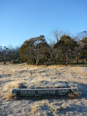
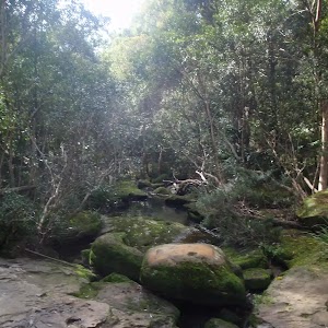
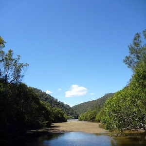
Dead Horse Gap is a relativley low mountain pass in the Great Dividing Range at 1582m AMSL. It was once a meeting place for Aboriginal groups in the summer, where they would perform ceremonies and trade with each other. In nature the pass acts as a funnel for the migration of insects and birds[14]. In the early 20th century, the pass became increasingly popular with stockmen, who brought sheep and cattle to the mountains each summer.[15]
(7.02km) Int Thredbo River and Dead Horse Gap tracks → Thredbo River track western bridge
1.1 km
23 mins
8m
-68m
Moderate track
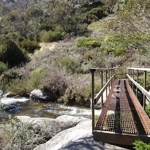
Veer left: From the intersection, this walk follows the ‘Thredbo village 4km’ sign[16] gently downhill whilst keeping the valley (and road) to your right. The track gently undulates along the side of the valley and after about 600m the track leads over a series of metal erosion control grates[17]. The walk continues crossing a series of these grates for about another 600m before leading down a long series of steps[18] to find a large metal bridge[19].
(8.09km) Thredbo River western bridge → Thredbo River eastern bridge
340 m
7 mins
6m
-15m
Moderate track
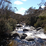
Continue straight: From the small clearing[20], this walk crosses Thredbo River using the long metal bridge[21]. This walk then turns left and heads through the grassy flat (initially over a metal grate[22]) enjoying the scattering of snow gums[23]. Before too long the track comes closer to the river again the leads down a log lined set of stairs[24] to cross the Thredbo River again on another metal bridge[25].
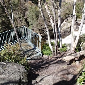
(8.43km) Int of Thredbo River track at eastern bridge → Cascades lookout
470 m
9 mins
8m
-21m
Moderate track
Continue straight: From the bridge, this walk crosses to the north side of the river and follows the bush track downstream, winding down the hill and through the snowgum forest. The walk continues along a metal walkway followed by a wooden boardwalk, then heads down a long hill to the intersection at the Thredbo River Cascades lookout platform.
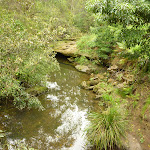
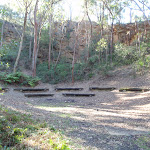
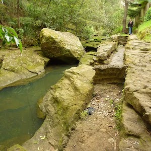
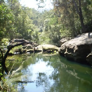
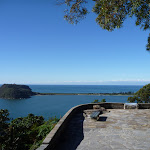
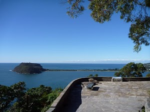
Cascades Lookout
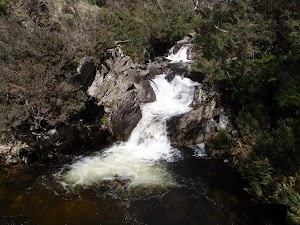
This metal platform leans over the Thredbo River, lookout upstream to the flowing cascades. There is also a wooden seat provided here, making it a great rest stop, conveniently situated about half way between Dead Horse Gap and Thredbo Village, on the Thredbo River track.
(8.9km) Cascades lookout → Int of Thredbo River and golf course tracks
1.3 km
27 mins
12m
-69m
Moderate track
Continue straight: From the lookout, this walk winds down the hill following the Thredbo River track as it continues along the creek, winding through the snow gum forest and crossing several metal walkways, continuing down some wooden steps until coming to the signposted intersection of the golf course loop track.
(10.19km) Int of Thredbo River and Golf Course Walk tracks → Int of Riverside Walk and Thredbo River bridge
810 m
15 mins
1m
-30m
Moderate track
Continue straight: From the intersection, this walk heads away from the face of the ‘Thredbo River Track’ sign[26] to follow the track east down the hill. The track leads down a series of steps the gently meanders along the side of the Thredbo River. Soon after passing the the green timber pump house[27], this walk comes to an intersection beside a small timber bridge[28] (that heads over a small creek onto the golf course).
Continue straight: From the intersection[29], this walk follows the track away from the golf course down the gentle hill and over a small metal bridge[30], keeping the main river to your right[31]. The track leads through the bush between the golf course and the river, crossing several sections of metal walkways[32] until winding back up to the golf course to soon come to an intersection at a large wooden bridge[33] (that crosses Thredbo River).
Continue straight: From the intersection[29], this walk follows the track away from the golf course down the gentle hill and over a small metal bridge[30], keeping the main river to your right[31]. The track leads through the bush between the golf course and the river, crossing several sections of metal walkways[32] until winding back up to the golf course to soon come to an intersection at a large wooden bridge[33] (that crosses Thredbo River).
(11km) Int of Riverside Walk and Thredbo River bridge → Int behind the community centre
80 m
2 mins
0m
-3m
Moderate track
Continue straight: From the timber bridge[34], this walk follows the clear track[35] keeping the river to your right. The track soon leads around the edge of the golf course and over a short metal bridge[36]. About 30m after this track leads to an intersection[37] (where the track on the right leads down to the creek), behind the community centre.
(11.08km) Int behind the community centre → Thredbo Memorial Community Centre
120 m
2 mins
1m
-4m
Moderate track
Thredbo Golf Course
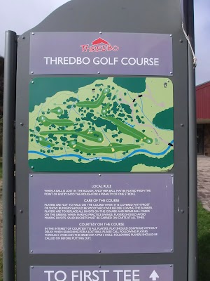
This nine hole AGU (Australian Golf Union) rated course is the highest in Australia. Nestled in beside Thredbo village, and bordering the Thredbo River, this course offers a great form of relaxation, and gives golfers a wonderful way to enjoy the Snowies, without having to travel too far from the village. More info.
(11.2km) Thredbo Memorial Community Centre → Bottom of Kosciuszko Express chairlift
480 m
9 mins
10m
-11m
Very easy
Turn right: From the Community Centre[42], this walk follows the road across the bridge[43], over Thredbo River to come to a signposted intersection with ‘Friday Drive’[44].
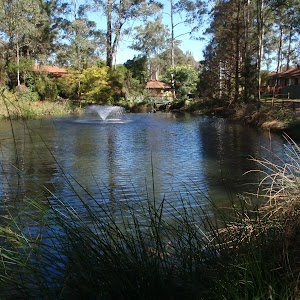
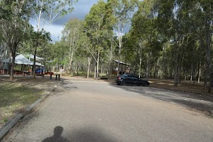
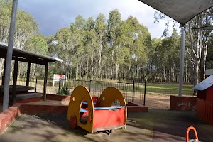
Turn left: From the intersection, this walk heads downhill following the ‘Friday Drive’ sign[45] past the pond (on your right). The road leads through a car park and past the children’s play ground[46]. In time the walk follow the footpath beside the road[47] that leads under a footbridge[48], where this walk then turns left across the road bridge[49]. Here the walk tends left up the road to find a large map[50] and the entrance to the tickets station[51] at the bottom of Kosciuszko Express chairlift.
Turn left: From the intersection, this walk heads downhill following the ‘Friday Drive’ sign[45] past the pond (on your right). The road leads through a car park and past the children’s play ground[46]. In time the walk follow the footpath beside the road[47] that leads under a footbridge[48], where this walk then turns left across the road bridge[49]. Here the walk tends left up the road to find a large map[50] and the entrance to the tickets station[51] at the bottom of Kosciuszko Express chairlift.
Maps for the Dead Horse Gap Loop track walk
You can download the PDF for this walk to print a map.
These maps below cover the walk and the wider area around the walk, they are worth carrying for safety reasons.
| Perisher Valley | 1:25 000 Map Series | 85252S PERISHER VALLEY | NSW-85252S |
| Chimneys Ridge | 1:25 000 Map Series | 85241N CHIMNEYS RIDGE | NSW-85241N |
| Kosciuszko | 1:100 000 Map Series | 8525 KOSCIUSZKO | 8525 |
| Jacobs River | 1:100 000 Map Series | 8524 JACOBS RIVER | 8524 |
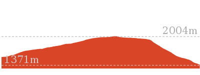
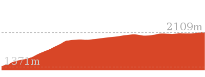
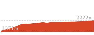
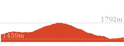
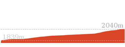
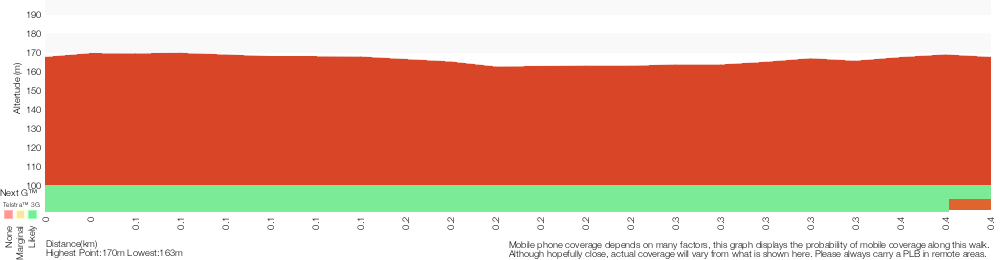
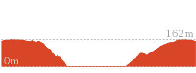
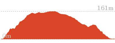
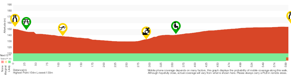
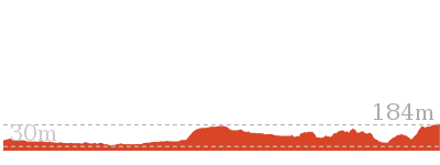
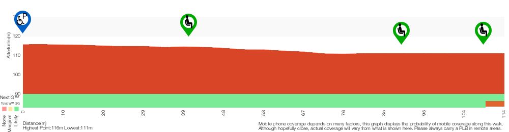
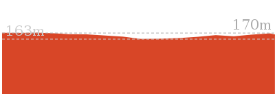
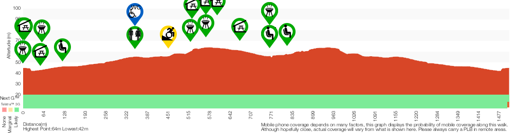
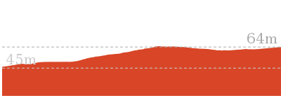
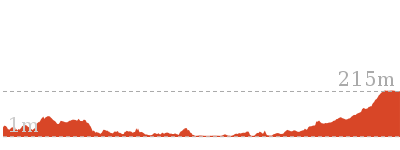
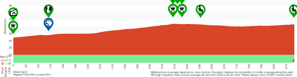
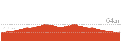
Cross sectional view of the Dead Horse Gap Loop track bushwalking track
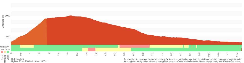
Analysis and summary of the altitude variation on the Dead Horse Gap Loop track
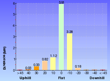
Overview of this walks grade – based on the AS 2156.1 – 2001
Under this standard, a walk is graded based on the most difficult section of the walk.
| Length | 9.8 km | ||
| Time | 4 hrs 30 mins | ||
| . | |||
| Grade 4/6 Hard track |
AS 2156.1 | Gradient | Short steep hills (3/6) |
| Quality of track | Formed track, with some branches and other obstacles (3/6) | ||
| Signs | Directional signs along the way (3/6) | ||
| Experience Required | Some bushwalking experience recommended (3/6) | ||
| Weather | Forecast, unforecast storms and severe weather may impact on navigation and safety (4/6) | ||
| Infrastructure | Limited facilities, not all cliffs are fenced (3/6) |
Some more details of this walks Grading
Here is a bit more details explaining grading looking at sections of the walk
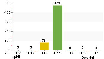
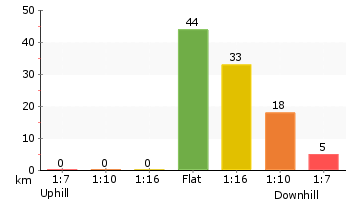
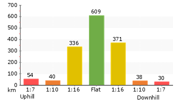
Gradient
5km of this walk has short steep hills and another 4km has gentle hills with occasional steps. The remaining (2.4km) is flat with no steps.
Quality of track
8km of this walk follows a formed track, with some branches and other obstacles and another 2.7km follows a smooth and hardened path. The remaining (890m) follows a clear and well formed track or trail.
Signs
Around 7km of this walk is clearly signposted, whilst the remaining 4.9km has directional signs at most intersection.
Experience Required
Around 8km of this walk requires some bushwalking experience, whilst the remaining 4.2km requires no previous bushwalking experience.
weather
8km of this walk is not usually affected by severe weather events (that would unexpectedly impact safety and navigation) and another 2.8km is affected by storms that may impact your navigation and safety. The remaining (1.3km) is affected by forecast, unforecast storms and severe weather events that may impact on navigation and safety.
Infrastructure
Around 8km of this walk is close to useful facilities (such as fenced cliffs and seats), whilst the remaining 3.5km has limited facilities (such as not all cliffs fenced).
Similar walks
A list of walks that share part of the track with the Dead Horse Gap Loop track walk.
3.3 km Circuit
1 hr 15 mins
Moderate track

3.7 km Circuit
2 hrs 30 mins
Hard track

3.8 km Return
2 hrs 30 mins
Hard track

4.1 km Return
1 hr 45 mins
Moderate track

4.7 km Return
2 hrs
Moderate track

4.8 km One way
1 hr 45 mins
Moderate track

5.3 km One way
3 hrs
Hard track
5.8 km Circuit
3 hrs
Hard track
7.5 km Return
3 hrs 45 mins
Hard track
10.1 km Circuit
5 hrs
Hard track

12.2 km One way
5 hrs
Hard track
12.4 km Return
6 hrs
Hard track
25.8 km One way
2 Days
Experienced only
Other Nearby walks
A list of walks that start near the Dead Horse Gap Loop track walk.
3.1 km Circuit
1 hr 30 mins
Hard track

3.3 km Circuit
1 hr 15 mins
Moderate track

2.2 km Return
1 Hr
Hard track
2.9 km Circuit
1 hr 15 mins
Moderate track
9.7 km Return
4 hrs
Hard track

19.6 km Return
7 hrs 30 mins
Hard track

778 m Return
30 mins
Moderate track

2.4 km Return
1 hr 30 mins
Hard track
4.2 km Circuit
2 hrs 15 mins
Hard track

3.8 km Return
1 hr 45 mins
Hard track
15.2 km Return
5 hrs 30 mins
Hard track
12 km Return
4 hrs 30 mins
Hard track
Plan your trip to and from the walk here
The Dead Horse Gap Loop track walk starts and ends at the Bottom of Kosciuszko Express chairlift (gps: -36.503981, 148.30397)
Your main transport option to Bottom of Kosciuszko Express chairlift is by;
![]() Car. A park entry fee is required for driving into the park.
Car. A park entry fee is required for driving into the park.
(get details)


Short URL = http://wild.tl/ww
Gallery images
There are other downloads I am still working on.
You will probably need to login to access these — still all free.
* KML (google earth file)
* GPX (GPS file)
Special Maps/ brochures
* A3 topo maps
* PDF with Lands Topo map base
* PDF with arial image (and map overlay)
I wanted to get the main site live first, this extra stuff will come in time.
Happy walking
Matt 🙂
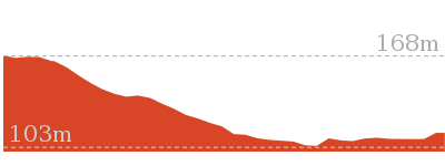
Red Hands Cave
And Walk
Red Hands Cave

30 mins
403 m Circuit
9 m
Moderate track
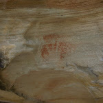
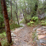
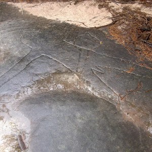
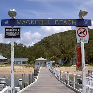
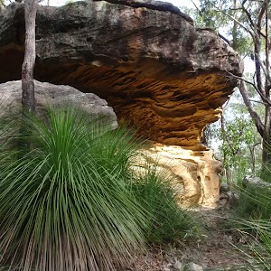
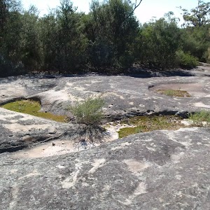
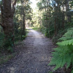
This is a short walk down to Red Hands Cave from the Resolute Picnic Area. The walk loops from the picnic area through the heath and down to the overhang of the cave. The Aboriginal rock art is quite faded but is estimated to be over 2000 years old. This makes for an interesting historic walk, great as an appetiser before a picnic lunch at Resolute Picnic Area.
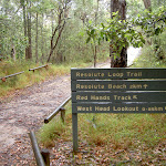


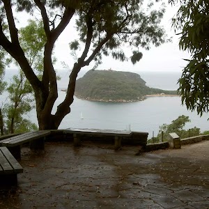
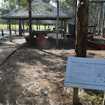
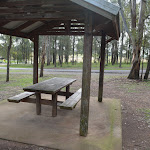
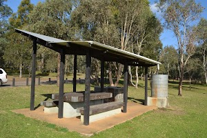
Resolute Picnic Area
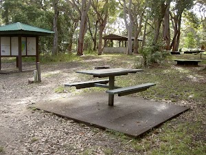
Resolute picnic area, Ku-ring-gai Chase National Park, is a large grassed area with benches, shelter, interpretive signs, electric BBQ’s and an environmentally-friendly toilet block. The picnic area does not have drinking water, but does have a pay phone and wheelchair-accessible bathroom with baby-changing area. Resolute picnic area is a great place for lunch, with Red Hands Cave, West Head and Resolute Beach and West Head Lookout tracks starting from the picnic area. The picnic area has adequate parking and a bus turn-around area.
(0km) Resolute Picnic Area → Red Hands Cave
250 m
4 mins
2m
-8m
Moderate track
From Resolute Picnic Area, this walk follow the signs for ‘Red Hands Cave’ away from the picnic area. The track heads down the sandy service trail for approximately 100m to the intersection marked by the sign on the left.
Turn left: From the intersection, this walk follows the sign to ‘Red Hands Cave 0.85km’ away from the service trail. The track heads slightly downhill before turning right. The track then drops down some stairs, passing around and down a rock shelf to continue to an overhanging rock – Red Hands Cave. The cave is fenced off and marked with informative signs.
Turn left: From the intersection, this walk follows the sign to ‘Red Hands Cave 0.85km’ away from the service trail. The track heads slightly downhill before turning right. The track then drops down some stairs, passing around and down a rock shelf to continue to an overhanging rock – Red Hands Cave. The cave is fenced off and marked with informative signs.
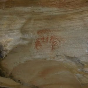
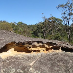
Red Hands Cave
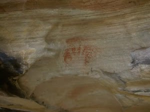
Red Hands Cave, Ku-ring-gai Chase National Park, is a small rock overhang just near Resolute Picnic Area. The red hands are made by ochre, clay, being blown over an outspread hand. This Aboriginal rock art has been given an estimation of approximately 2000 years in age.
(0.25km) Red Hands Cave → Resolute Picnic Area
150 m
3 mins
7m
-1m
Moderate track
Continue straight: From Red Hands Cave, the walk heads up the slight hill keeping the rocky outcrop to the left of the track. The walk leads approximately 30m to a signposted intersection.
Continue straight: From the intersection, the walk heads along the rocky outcrop keeping it on the left as it heads up the stairs for approximately 30m into Resolute Picnic Area.
Continue straight: From the intersection, the walk heads along the rocky outcrop keeping it on the left as it heads up the stairs for approximately 30m into Resolute Picnic Area.
Maps for the Red Hands Cave walk
You can download the PDF for this walk to print a map.
These maps below cover the walk and the wider area around the walk, they are worth carrying for safety reasons.
| Broken Bay | 1:25 000 Map Series | 91301N BROKEN BAY | NSW-91301N |
| Ku-ring-gai Chase National Park Tourist Map | 1:40 000 Map Series | CMA Ku-ring-gai Chase National Park Tourist Map | CMA Ku-ring-gai Chase National Park Tourist Map |
| Sydney | 1:100 000 Map Series | 9130 SYDNEY | 9130 |
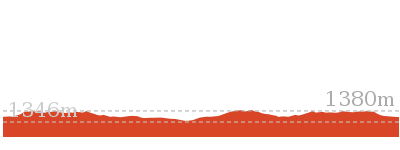
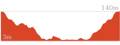
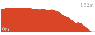
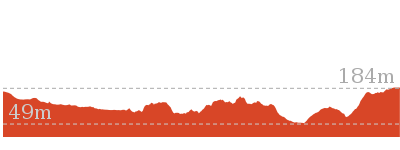
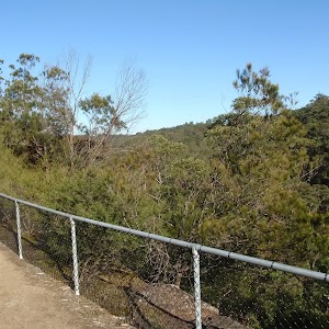
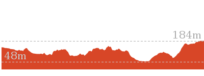
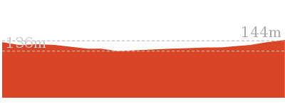
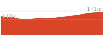
Cross sectional view of the Red Hands Cave bushwalking track
Analysis and summary of the altitude variation on the Red Hands Cave
Overview of this walks grade – based on the AS 2156.1 – 2001
Under this standard, a walk is graded based on the most difficult section of the walk.
| Length | 403 m | ||
| Time | 30 mins | ||
| . | |||
| Grade 3/6 Moderate track |
AS 2156.1 | Gradient | Short steep hills (3/6) |
| Quality of track | Formed track, with some branches and other obstacles (3/6) | ||
| Signs | Clearly signposted (1/6) | ||
| Experience Required | No experience required (1/6) | ||
| Weather | Weather generally has little impact on safety (1/6) | ||
| Infrastructure | Limited facilities, not all cliffs are fenced (3/6) |
Some more details of this walks Grading
Here is a bit more details explaining grading looking at sections of the walk
Gradient
Around 270m of this walk has gentle hills with occasional steps, whilst the remaining 130m has short steep hills.
Quality of track
This whole walk, 400m follows a formed track, with some branches and other obstacles.
Signs
This whole walk, 400m is clearly signposted.
Experience Required
This whole walk, 400m requires no previous bushwalking experience.
weather
This whole walk, 400m is not usually affected by severe weather events (that would unexpectedly impact safety and navigation).
Infrastructure
Around 290m of this walk is close to useful facilities (such as fenced cliffs and seats), whilst the remaining 120m has limited facilities (such as not all cliffs fenced).
Similar walks
A list of walks that share part of the track with the Red Hands Cave walk.
1.1 km Circuit
45 mins
Moderate track
1.9 km Return
1 Hr
Moderate track
3.5 km Circuit
1 hr 45 mins
Hard track

3.7 km Return
1 hr 30 mins
Hard track

5.4 km Circuit
3 hrs
Hard track
8.6 km Circuit
5 hrs
Hard track

Other Nearby walks
A list of walks that start near the Red Hands Cave walk.
810 m Circuit
30 mins
Moderate track


238 m Return
10 mins
Easy track

2.8 km Circuit
1 hr 30 mins
Very experienced only

2.1 km Return
1 Hr
Moderate track

1.9 km Return
1 Hr
Hard track
1.4 km Circuit
45 mins
Moderate track


2.3 km Return
1 hr 30 mins
Hard track
8.2 km Return
3 hrs
Hard track
5.9 km Circuit
3 hrs
Hard track
5.6 km Return
2 hrs 30 mins
Moderate track
3 km Return
1 hr 15 mins
Moderate track

4.5 km One way
1 hr 45 mins
Hard track
Plan your trip to and from the walk here
The Red Hands Cave walk starts and ends at the Resolute Picnic Area (gps: -33.577895, 151.30009)
Your main transport option to Resolute Picnic Area is by;
![]() Car. A park entry fee is required for driving into the park.
Car. A park entry fee is required for driving into the park.
(get details)
Short URL = http://wild.tl/r
Gallery images
There are other downloads I am still working on.
You will probably need to login to access these — still all free.
* KML (google earth file)
* GPX (GPS file)
Special Maps/ brochures
* A3 topo maps
* PDF with Lands Topo map base
* PDF with arial image (and map overlay)
I wanted to get the main site live first, this extra stuff will come in time.
Happy walking
Matt 🙂
Bellamy fire trail
And Walk
Bellamy fire trail

30 mins
619 m One way
34 m
Moderate track
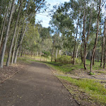
This walk follows a wide concrete trail through Berowra Valley Regional Park, through lovely bushland and the site of the historic Zig Zag railway. The railway is long gone, but the quarry site is interesting to explore and crossing Zig Zag Creek on the bridge gives a lovely view down on the fern trees. Stop and read the information signs along the way, bring your dog for a walk or use this trail for fitness training. The trail on the north side of Zig Zag Creek is very steep for about 50m, otherwise, this walk is easy to follow. To save the car shuttle you can just allow extra time and retrace your steps back to the start.


(0km) End of Bellamy St → Int of Bellamy trail and Morgan Rd tracks
90 m
2 mins
0m
-10m
Easy track
From the end of Bellamy St (Pennant Hills), the walk passes around the locked metal gate[1]

and follows the ‘To Westleigh’ arrow[2] downhill along the concrete management trail. After about 25m this walk leads past a picnic table

[3] (on the left) then over the next 50m this walk continues downhill past the ‘Halls Camp’ information sign[4], the ‘Natures Filter’[5] to come to an intersection with a dirt track (the Great North Walk) marked with an arrow pointing back up to ‘Bellamy Street’[6].
(0.09km) Int of Bellamy trail and Morgan Rd tracks → Zig Zag Creek Bridge int.
130 m
2 mins
0m
-6m
Easy track
Continue straight: From the intersection, this walk follows the ‘The Jungo’ arrow[7] downhill along the wide concrete trail for 25m to cross over the culverted creek[8] (with a green rail[9] on one side)

. The walk continues down into the valley[10] along the concrete trail for another 110m to come to a signposted intersection marked with a ‘Great North Walk’ sign[11][12] (on your left), just before ‘Zig Zag Creek’[13] and the long bridge[14].
Thornleigh zigzag railway
The Thornleigh zigzag railway originally ran from the main rail line near Thornleigh to a historic quarry, near present day De Saxe Cl, Thornleigh. There are only minor fragments still visible today. The ‘Heritage Trail’ in Thornleigh has interpretive signs for the railway and the old Thornleigh Quarry. A book is available with some detail on railway and associated quarry: ‘Sydney’s Forgotten Quarry Railways’ by John Oakes, ISBN 0 9757870 3 9
(0.22km) Zig Zag Creek Bridge int → Thornleigh Quarry
160 m
4 mins
15m
-8m
Moderate track
Continue straight: From the intersection, the walk heads gently downhill to then cross ‘Zig Zag Creek’[15] on the 40m long bridge[16] (with handrails) to find the ‘Zig Zag Siding’ information sign[17][18] on the far side. The bridge path now merges back to the main wide trail[19] and heads steeply uphill[20] for about 50m

(with a handrail on the left side[21]). The trail then mostly flattens out for about 50m and leads gently up to the front of the old ‘Thornleigh Quarry’[22], marked with a plaque on a large stone[23][24][25]

.
Old Thornleigh Quarry
The old Thornleigh Quarry[26] is located beside the Heritage Trail in Thornleigh, within Berowra Valley Regional Park. The quarry dates back to 1883 and was initially a source of ‘ballast’ for portions of the Sydney (Homebush) to Newcastle (Waratah) rail link. There is a firm, flat dirt track[27] that leads about 40m from the concrete trail to the centre of the old quarry[28]. You will find a series of log seats in this amphitheatre
making this a pleasant spot to sit and enjoy the intriguing mix of nature and history. A book is available with some detail on this quarry and the associated zigzag railway: ‘Sydney’s Forgotten Quarry Railways’ by John Oakes, ISBN 0 9757870 3 9
(0.37km) Thornleigh Quarry → Int of Heritage Trail and De Saxe Cl trail
110 m
3 mins
11m
0m
Very easy
Continue straight: From the front of the old Thornleigh Quarry[29][30], this walk follows the wide concrete trail gently uphill, initially keeping the quarry to the right, passing ‘The Quarry’ information sign[31]. The trail meanders through the bush for about 100m to come to an intersection at the base of a set of timber stairs[32] (on the right).
(0.48km) Int of Heritage Trail and De Saxe Cl trail → End of Timbarra Rd
140 m
3 mins
8m
-3m
Easy track
Continue straight: From the intersection, this walk follows the concrete management trail gently uphill keeping the valley to the left. After about 40m the trail leads along the side of a small rock wall[33] to pass a ‘Berowra Valley Regional Park’ map sign[34] then about 25m later the trail leads past the old girl guide hall[35]. The walk continues along the concrete trail for another 50m to pass a ‘Heritage Trail’[36] sign then head around the gate[37]

Maps for the Bellamy fire trail walk
You can download the PDF for this walk to print a map.
These maps below cover the walk and the wider area around the walk, they are worth carrying for safety reasons.
| Hornsby | 1:25 000 Map Series | 91304S HORNSBY | NSW-91304S |
| Sydney | 1:100 000 Map Series | 9130 SYDNEY | 9130 |
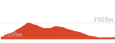
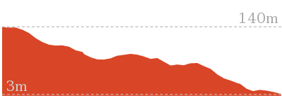
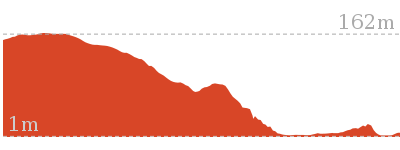
Cross sectional view of the Bellamy fire trail bushwalking track
Analysis and summary of the altitude variation on the Bellamy fire trail
Accessibility summary information for the Bellamy fire trail
Parking: There are 0 designated accessible parking areas on this walk.
Toilets: There are 0 designated accessible toilets on this walk.
Seats: There are 2 places to sit on this walk.
They are 350m apart.
Hazards: There are 2 specific noteable accessability related hazards on this walk.
Trip Hazard Unfenced and unmarked edge with potential 80cm or higher fall into the creek. Keep clear of the culverts edge when crossing. Found about 110m into the walk.
Wheelchair Steep A 45m long section of concrete trail (3.3m wide) that is very steep. There is a metal handrail on one side for most of the steep section. If using a wheelchair assistance is very likely required. Found about 300m into the walk.
Accessibility Details

Found 0m into this walk
Found 30m into this walk

Found 300m into this walk


Overview of this walks grade – based on the AS 2156.1 – 2001
Under this standard, a walk is graded based on the most difficult section of the walk.
| Length | 619 m | ||
| Time | 30 mins | ||
| . | |||
| Grade 3/6 Moderate track |
AS 2156.1 | Gradient | Short steep hills (3/6) |
| Quality of track | Clear and well formed track or trail (2/6) | ||
| Signs | Clearly signposted (1/6) | ||
| Experience Required | No experience required (1/6) | ||
| Weather | Weather generally has little impact on safety (1/6) | ||
| Infrastructure | Generally useful facilities (such as fenced cliffs and seats) (1/6) |
Some more details of this walks Grading
Here is a bit more details explaining grading looking at sections of the walk
Gradient
250m of this walk is flat with no steps and another 220m has gentle hills with occasional steps. The remaining (160m) has short steep hills.
Quality of track
Around 480m of this walk follows a smooth and hardened path, whilst the remaining 140m follows a clear and well formed track or trail.
Signs
This whole walk, 620m is clearly signposted.
Experience Required
This whole walk, 620m requires no previous bushwalking experience.
weather
This whole walk, 620m is not usually affected by severe weather events (that would unexpectedly impact safety and navigation).
Infrastructure
This whole walk, 620m is close to useful facilities (such as fenced cliffs and seats).
Similar walks
A list of walks that share part of the track with the Bellamy fire trail walk.
529 m One way
15 mins
Moderate track

4.2 km Circuit
1 hr 45 mins
Hard track

4.4 km One way
1 hr 45 mins
Moderate track
6.6 km Circuit
2 hrs 30 mins
Hard track
8.6 km One way
3 hrs 45 mins
Hard track
10.2 km One way
4 hrs
Hard track
15.5 km One way
6 hrs
Hard track

17.5 km One way
6 hrs 45 mins
Hard track


20.6 km One way
8 hrs
Hard track

25.8 km One way
2 Days
Hard track

28.1 km One way
2 Days
Hard track

35.9 km One way
2 Days
Hard track


44.4 km One way
3 Days
Hard track

Other Nearby walks
A list of walks that start near the Bellamy fire trail walk.
6.1 km One way
2 hrs 30 mins
Hard track
8.2 km Circuit
3 hrs
Hard track
2.5 km Return
1 hr 30 mins
Hard track
828 m Return
30 mins
Moderate track
717 m Circuit
20 mins
Very easy


5.1 km Circuit
2 hrs
Hard track
9 km One way
3 hrs 45 mins
Hard track
4.1 km One way
1 hr 45 mins
Moderate track
439 m Circuit
15 mins
Moderate track
2.2 km One way
1 Hr
Moderate track
515 m One way
15 mins
Moderate track
Plan your trip to and from the walk here
The Bellamy fire trail walk starts at the End of Bellamy St (gps: -33.728765, 151.06981)
Your main transport option to End of Bellamy St is by;
![]() Car. There is free parking available.
Car. There is free parking available.
(get details)
The Bellamy fire trail ends at the End of Timbarra Rd (gps: -33.724319, 151.07005)
Your main transport option to End of Timbarra Rd is by;
![]() Car. There is free parking available.
Car. There is free parking available.
(get details)
Short URL = http://wild.tl/bft
Gallery images
There are other downloads I am still working on.
You will probably need to login to access these — still all free.
* KML (google earth file)
* GPX (GPS file)
Special Maps/ brochures
* A3 topo maps
* PDF with Lands Topo map base
* PDF with arial image (and map overlay)
I wanted to get the main site live first, this extra stuff will come in time.
Happy walking
Matt 🙂
West Head Lookout
And Walk
West Head Lookout

10 mins
238 m Return
18 m
Easy track
This walk is all about the stunning views from the edge of West Head. After the lovely drive through the bushland along the West Head Rd you will love this gentle stroll down to what feels like the edge of the earth. There are great views across the Pittwater to Barenjoey Head as well as across the mouth of the Hawkesbury River. You will find plenty of information signs explaining some of the rich histories of the area, including about the gun emplacements that were built into the side of the cliffs here to protect from enemy ship invasion. Make a day of it by packing a picnic lunch and visiting Resolute picnic ground (and toilets) about 900m back along the road.


(0km) End of West Head Rd → Lion Island View
50 m
1 mins
4m
-5m
Very easy
From the end of West Head Rd (Ku-Ring-Gai Chase)

, this walk follows the flat sandstone paved path around the metal bollard[1], past the large ‘West Head Lookout’[2] sign, ignoring the ‘West Head Army Track’[3]. After about 20m the path widens significantly[4] and this walk continues gently downhill towards the views to come to the Lion Island viewing area[5] (at the top of set of steps[6]) with 4 seats

, marked with a series of ‘West Head Battery’ signs[7].
Lion Island View
(0.05km) Lion Island View → West Head Lookout
30 m
1 mins
0m
-5m
Easy track
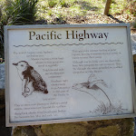
Continue straight: From the viewing area, this walk heads towards the main water views down the 7 sandstone stone steps[11] (each 10cm high). At the bottom of the steps, this walk leads past the ‘Pacific Highway’ information sign[12] and continues down the path for another 20m to come to the main West Head Lookout area[13][14]. Now Veer right to rejoin the main walk .
(0.05km) Lion Island View → West Head Lookout
70 m
2 mins
2m
-7m
Easy track
Turn right: From the Lion Island viewing area[15], this walk heads directly away from the face of the ‘West Head Battery’ signs[16], past the top of the steps (initially keeping the steps to the left[17]). The walk soon veers left (at the seats) and follows the narrow (1.3m wide) stone path[18] as it gently winds downhill for about 40m to come to some more bench seats

[19] at the southern edge of the main West Head Lookout. From here the walk veers left and heads along the wide stone lookout area[20], passing some more seats

and information signs[21][22][23][24] coming to a panoramic photo sign naming the key view points[25].
West Head Lookout
West Head Lookout, Ku-ring-gai Chase National Park is a large paved sandstone viewing area[26] with fantastic views and some interesting interpretive signs[27][28][29][30][31]. The view spans across the Hawkesbury River to Lion Island[32] to Patonga (Central Coast) also across the Pittwater to Barrenjoey Headland[33] and out to sea. The lookout has a series of bench seats
and a low (50cm[34]) stone wall. A lovely place to just sit and soak up the views, and history of the area.
Maps for the West Head Lookout walk
You can download the PDF for this walk to print a map.
These maps below cover the walk and the wider area around the walk, they are worth carrying for safety reasons.
| Broken Bay | 1:25 000 Map Series | 91301N BROKEN BAY | NSW-91301N |
| Ku-ring-gai Chase National Park Tourist Map | 1:40 000 Map Series | CMA Ku-ring-gai Chase National Park Tourist Map | CMA Ku-ring-gai Chase National Park Tourist Map |
| Sydney | 1:100 000 Map Series | 9130 SYDNEY | 9130 |
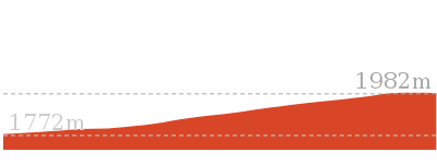
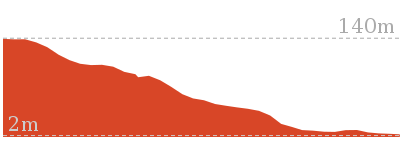
Cross sectional view of the West Head Lookout bushwalking track
Analysis and summary of the altitude variation on the West Head Lookout
Accessibility summary information for the West Head Lookout
Parking: There are 1 designated accessible parking areas on this walk.
Toilets: There are 0 designated accessible toilets on this walk.
Seats: There are 3 places to sit on this walk.
They are on average 50m apart, with a maximum gap of 50m.
Hazards: There are 0 specific noteable accessability related hazards on this walk.
Toilets: There are 0 designated accessible toilets on this walk.
Seats: There are 3 places to sit on this walk.
They are on average 50m apart, with a maximum gap of 50m.
Hazards: There are 0 specific noteable accessability related hazards on this walk.
Accessibility Details

Found 0m into this walk


Overview of this walks grade – based on the AS 2156.1 – 2001
Under this standard, a walk is graded based on the most difficult section of the walk.
| Length | 238 m | ||
| Time | 10 mins | ||
| . | |||
| Grade 2/6 Easy track |
AS 2156.1 | Gradient | Flat, no steps (1/6) |
| Quality of track | Clear and well formed track or trail (2/6) | ||
| Signs | Clearly signposted (1/6) | ||
| Experience Required | No experience required (1/6) | ||
| Weather | Weather generally has little impact on safety (1/6) | ||
| Infrastructure | Generally useful facilities (such as fenced cliffs and seats) (1/6) |
Some more details of this walks Grading
Here is a bit more details explaining grading looking at sections of the walk
Gradient
This whole walk, 120m is flat with no steps.
Quality of track
Around 70m of this walk follows a clear and well formed track or trail, whilst the remaining 45m follows a smooth and hardened path.
Signs
This whole walk, 120m is clearly signposted.
Experience Required
This whole walk, 120m requires no previous bushwalking experience.
weather
This whole walk, 120m is not usually affected by severe weather events (that would unexpectedly impact safety and navigation).
Infrastructure
This whole walk, 120m is close to useful facilities (such as fenced cliffs and seats).
Similar walks
A list of walks that share part of the track with the West Head Lookout walk.
Other Nearby walks
A list of walks that start near the West Head Lookout walk.
810 m Circuit
30 mins
Moderate track
403 m Circuit
30 mins
Moderate track
1.1 km Circuit
45 mins
Moderate track
3.7 km Return
1 hr 30 mins
Hard track
3.5 km Circuit
1 hr 45 mins
Hard track
1.9 km Return
1 Hr
Moderate track
2.8 km Circuit
1 hr 30 mins
Very experienced only
2.1 km Return
1 Hr
Moderate track
1.9 km Return
1 Hr
Hard track
2.3 km Return
1 hr 30 mins
Hard track
1.4 km Circuit
45 mins
Moderate track
5.4 km Circuit
3 hrs
Hard track
Plan your trip to and from the walk here
The West Head Lookout walk starts and ends at the End of West Head Rd (gps: -33.578828, 151.30857)
Your main transport option to End of West Head Rd is by;
![]() Car. A park entry fee is required for driving into the park.
Car. A park entry fee is required for driving into the park.
(get details)
Short URL = http://wild.tl/whlw
Gallery images
There are other downloads I am still working on.
You will probably need to login to access these — still all free.
* KML (google earth file)
* GPX (GPS file)
Special Maps/ brochures
* A3 topo maps
* PDF with Lands Topo map base
* PDF with arial image (and map overlay)
I wanted to get the main site live first, this extra stuff will come in time.
Happy walking
Matt 🙂
Rouse Hill Path circuit
And Walk
Rouse Hill Path circuit

45 mins
1.5 km Circuit
31 m
Moderate track
Whether on foot or wheels this is a pleasant stroll around the asphalt bike track and footpath through Rouse Hill Regional Park. A great adventure for kids or for adults wanting to ramble through eucalypt forest, parkland and old farm. Starting from the great playground and picnic area you will follow the footpath past plenty of picnic tables with a toilet near the start and along the way. A pleasant way to stretch the legs.


Rouse Hill main car park
The main car park is found at the end of the 750m long driveway off Worcester Rd, Rouse Hill. There is room to park about 60 cars in the shade of the tall trees[1]. There is no signposted mobility parking but each parking bay is marked and 2.7m wide.
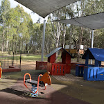
Rouse Hill main Picnic area and playground
Nestled among the tall eucalypt forest at the southern end of the main car park in Rouse Hill Regional Park is a lovely playground, picnic area and toilet block.
The well equiped children’s playground has a timber maze[2], climbing equipment[3], slides[4], and other equpment[5][6][7].
The picnic facilities between the car park and the playground include two large sheltered tables
The well equiped children’s playground has a timber maze[2], climbing equipment[3], slides[4], and other equpment[5][6][7].
The picnic facilities between the car park and the playground include two large sheltered tables
and BBQ’s

. There are other seats and picnic tables around the area as well. About 20m west of the playground is a quieter elevated picnic shelter

and BBQ

.
There is a toilet block


about 150m walk from the playground around the edge of the large clearing[8].
(0km) Rouse Hill main car park → Playground intersection
30 m
1 mins
0m
-1m
Easy track
From the southern edge of the main Rouse Hill Regional Park car park, this walk follows the concrete footpath, keeping the sheltered picnic areas
to the left for about 15m[9] to come to the ‘Welcome to Rouse Hill Regional Park’ sign[10]. From here this walk continues beside the playground, following the gravel track[11] for 15m come to a 4-way intersection marked with the large ‘Rouse Hill Regional Park’ sign[12].
(0.03km) Playground intersection → Pavilion Intersection
540 m
11 mins
20m
-4m
Moderate track
Turn right: From the intersection, this walk follows the asphalt footpath gently uphill directly away from the playground[13]. The path leads past the elevated picnic shelter
[14] (on the right) and after about 55m the walk veers left at an intersection[15] to lead past the orange metal bollard[16] (1.1m wide gap). About 15m later this walk comes to another 3-way intersection[17] with a (short timber bridge[18] on the right – that leads towards a series of seats

). This walk continues straight along the main asphalt path[19] (ignoring the side paths) for about 300m to leave the trees and continue moderately steeply uphill

through the open grassy area for about 140m, behind the picnic shelter
, to come to a 3-way intersection just before the road/driveway[20].
Turn left: From the intersection, this walk heads gently uphill[21] along the asphalt footpath, keeping the road a short distance to the right for about 30m to come to a paved intersection[22].
(0.57km) Pavilion Intersection → Pavilion toilet
80 m
1 mins
0m
0m
Very easy
Turn left: From the intersection, this walk heads directly away from the road, gently downhill along the asphalt path towards the picnic shelters. After about 15m this walk leads past the signposted ‘Crebra Pavilion’ picnic shelter[23]


. About another 20m later this path leads to the ‘Fibrosa Pavilion’ picnic shelter[24]


. The walk continues along the footpath for about 35m to come to the toilet block


(on the left) At the end of this side trip, retrace your steps back to the main walk then Turn left .
Crebra & Fibrosa Pavilions
Nestled in the trees in Rouse Hill Regional Park is this very well equipped picnic area. There are two large (11x12m) sheltered areas. Closest to the road is the ‘Crebra Pavilion’ picnic shelter[25] with two large tables
, a BBQ
and tank water
. About 20m away is the similarly designed ‘Fibrosa Pavilion’ picnic shelter[26]
. Further down the path, you will find the toilet block
with an accessible cubicle
. There is parking nearby and sloping open grassy areas around. These facilities can be booked for exclusive use. A lovely place to spend time with family or friends.
(0.57km) Pavilion Intersection → Western Picnic area int.
200 m
3 mins
1m
-6m
Easy track
Continue straight: From the intersection, this walk heads gently downhill along the asphalt footpath, keeping the road a short distance to the right. After 10m this walk leads around a metal orange bollard[29] (1.3m wide gap), then about 20m later leads past a picnic shelter[30]

(on the right). This walk continues along the path as it meanders downhill for another 70m to pass another picnic shelter[31]

(on the left). From here the walk continues down along the path for another 100m to a faint intersection, just before the road (as the path bends right) above the Western Picnic area


.
Western Picnic area
Just near the entrance (250m along driveway) of the Rouse Hill Regional Park is this queit and lovely picnic area. There are two sheltered picnic tables[32]
with BBQs[33]
. There is also a scattering of picnic platforms[34] and seats
. The picnic area is near an unfenced pond[35] and there is plenty of open grassy area around[36]. There is road side parking for about 6 cars[37]. A pleasant spot to stop while exploring the area.
(0.77km) Western picnic area int. → Tree hollow intersection
170 m
3 mins
5m
0m
Easy track
Turn right: From the intersection, this walk heads across the road/driveway[38] (watching for traffic) and follows the asphalt footpath gently uphill for 30m to come to a clear three-way intersection marked with a ‘Welcome to Rouse Hill Regional Park’ information sign[39] and a bench seat[40]

.
Continue straight: From the intersection, this walk heads uphill along the asphalt footpath as it winds through the open grassy area for 120m to pass a large dead tree[41] and comes to an intersection with a grassy trail[42] (on the left just as the path bends right near the road).
(0.95km) Tree hollow intersection → Rouse Hill main car park
580 m
12 mins
5m
-20m
Moderate track
Veer right: From the intersection, this walk follows the asphalt footpath towards[43] and then between the timber bollards[44] (1.2m gap), then across the road[45] (watch for traffic). This walk then follows the asphalt path on the other side of the road for about 10m to come to a three-way intersection[46] near the picnic shelters.
Continue straight: From the intersection, this walk follows the asphalt footpath downhill through the grassy clearing, away from the road and initially keeping the sheltered picnic area
Continue straight: From the intersection, this walk follows the asphalt footpath downhill through the grassy clearing, away from the road and initially keeping the sheltered picnic area
on the right. The path meanders mostly downhill and after 80m the path steepens
for a time then leads less steeply down for another 50m into a eucalypt forest. The walk then continues downhill along the path for 300m among the trees, ignoring the side paths to come to a 3-way intersection (with a short timber bridge[47] on the left, that leads to a series of seats
). The walk continues straight for about 15m to pass the orange metal bollard[48] (1.1m wide gap), then about 30m later this walk veers right at a 3-way intersection[49]. The walk continues down along the path past the elevated picnic shelter
for 55m to come to an intersection[50], just before the playground, marked with a large ‘Rouse Hill Regional Park’ sign[51] (on the right).
Turn left : From the intersection, this walk heads directly away from the face of ‘Rouse Hill Regional Park’ sign[52] along the gravel track, keeping the playground on the right. After about 15m this walk comes to a ‘Welcome to Rouse Hill Regional Park’ sign[53]. From here this walk follows the concrete path for 15m, past the sheltered picnic area
to come to the main Rouse Hill Regional Park car park[54].
Maps for the Rouse Hill Path circuit walk
You can download the PDF for this walk to print a map.
These maps below cover the walk and the wider area around the walk, they are worth carrying for safety reasons.
| Riverstone | 1:25 000 Map Series | 90301S RIVERSTONE | NSW-90301S |
| Penrith | 1:100 000 Map Series | 9030 PENRITH | 9030 |
Cross sectional view of the Rouse Hill Path circuit bushwalking track
Analysis and summary of the altitude variation on the Rouse Hill Path circuit
Accessibility summary information for the Rouse Hill Path circuit
Parking: There are 0 designated accessible parking areas on this walk.
Toilets: There are 1 designated accessible toilets on this walk.
Seats: There are 9 places to sit on this walk.
They are on average 100m apart, with a maximum gap of 480m.
Hazards: There are 1 specific noteable accessability related hazards on this walk.
Wheelchair Steep Two sections of this path (about 25m long) are moderately (1.6:12) steep. Found about 450m into the walk.
Accessibility Details

Found 0m into this walk

Found 0m into this walk
Found 0m into this walk

Found 50m into this walk


Found 350m into this walk


Found 520m into this walk


Found 570m into this walk

Found 600m into this walk

Found 670m into this walk
Found 770m into this walk


Overview of this walks grade – based on the AS 2156.1 – 2001
Under this standard, a walk is graded based on the most difficult section of the walk.
| Length | 1.5 km | ||
| Time | 45 mins | ||
| . | |||
| Grade 3/6 Moderate track |
AS 2156.1 | Gradient | Gentle hills with occasional steps (2/6) |
| Quality of track | Smooth and hardened path (1/6) | ||
| Signs | Directional signs along the way (3/6) | ||
| Experience Required | No experience required (1/6) | ||
| Weather | Weather generally has little impact on safety (1/6) | ||
| Infrastructure | Generally useful facilities (such as fenced cliffs and seats) (1/6) |
Some more details of this walks Grading
Here is a bit more details explaining grading looking at sections of the walk
Gradient
Around 1.4km of this walk has gentle hills with occasional steps, whilst the remaining 130m is flat with no steps.
Quality of track
This whole walk, 1.5km follows a smooth and hardened path.
Signs
Around 1km of this walk has directional signs at most intersection, whilst the remaining 510m is clearly signposted.
Experience Required
This whole walk, 1.5km requires no previous bushwalking experience.
weather
This whole walk, 1.5km is not usually affected by severe weather events (that would unexpectedly impact safety and navigation).
Infrastructure
This whole walk, 1.5km is close to useful facilities (such as fenced cliffs and seats).
Similar walks
A list of walks that share part of the track with the Rouse Hill Path circuit walk.
865 m Circuit
20 mins
Moderate track

1.8 km Return
45 mins
Easy track
Other Nearby walks
A list of walks that start near the Rouse Hill Path circuit walk.

499 m One way
15 mins
Easy track

12.9 km One way
5 hrs 30 mins
Hard track

12.6 km One way
5 hrs 30 mins
Hard track
1.4 km Return
30 mins
Moderate track
515 m One way
15 mins
Moderate track
2.2 km One way
1 Hr
Moderate track
5.1 km Circuit
2 hrs
Hard track
9 km One way
3 hrs 45 mins
Hard track
4.1 km One way
1 hr 45 mins
Moderate track
4.4 km One way
1 hr 45 mins
Moderate track
439 m Circuit
15 mins
Moderate track
4.2 km Circuit
2 hrs
Hard track

Plan your trip to and from the walk here
The Rouse Hill Path circuit walk starts and ends at the Rouse Hill main car park (gps: -33.680471, 150.91068)
Your main transport option to Rouse Hill main car park is by;
![]() Car. There is free parking available.
Car. There is free parking available.
(get details)
Short URL = http://wild.tl/rhpc
Gallery images
There are other downloads I am still working on.
You will probably need to login to access these — still all free.
* KML (google earth file)
* GPX (GPS file)
Special Maps/ brochures
* A3 topo maps
* PDF with Lands Topo map base
* PDF with arial image (and map overlay)
I wanted to get the main site live first, this extra stuff will come in time.
Happy walking
Matt 🙂
Rouse Hill Estate walk
And Walk
Rouse Hill Estate walk

45 mins
1.8 km Return
21 m
Easy track
This walk is a great way to step back in time and explore the old Rouse Hill Estate. There are optional side trips that take you to some well-equipped picnic areas if you have the extra time. The walk mostly follows wide grassy trails and gives you good views of the whole estate. There are a series of information signs that help give you a deeper understanding of the history of the area. A pleasant stroll around an old farm site.


Rouse Hill main car park
The main car park is found at the end of the 750m long driveway off Worcester Rd, Rouse Hill. There is room to park about 60 cars in the shade of the tall trees[1]. There is no signposted mobility parking but each parking bay is marked and 2.7m wide.
Rouse Hill main Picnic area and playground
Nestled among the tall eucalypt forest at the southern end of the main car park in Rouse Hill Regional Park is a lovely playground, picnic area and toilet block.
The well equiped children’s playground has a timber maze[2], climbing equipment[3], slides[4], and other equpment[5][6][7].
The picnic facilities between the car park and the playground include two large sheltered tables
The well equiped children’s playground has a timber maze[2], climbing equipment[3], slides[4], and other equpment[5][6][7].
The picnic facilities between the car park and the playground include two large sheltered tables
and BBQ’s
. There are other seats and picnic tables around the area as well. About 20m west of the playground is a quieter elevated picnic shelter
and BBQ
.
There is a toilet block
about 150m walk from the playground around the edge of the large clearing[8].
(0km) Rouse Hill main car park → Northern edge of main car park
100 m
2 mins
2m
-1m
Easy track
From the southern edge of the main Rouse Hill Regional Park car park, this walk heads through the asphalt car park to the large ‘Rouse Hill Estate Walk’ sign[9] near the car park exit.
(0.1km) Northern edge of main car park → Rebels intersection
430 m
7 mins
14m
0m
Easy track
Continue straight: From the northern edge of the car park, this walk follows the large ‘Rouse Hill Estate Walk’ sign[10] between the wide timber bollards and across the dirt trail for 20m to then cross rough gravel driveway [11]. The walk continues straight to follow the dirt and grassy trail as it winds uphill for 400m (ignoring the narrower side tracks) to find a ‘rebels’ information sign[12]. Less than 10m past this sign, this walk comes to a t-intersection marked with a ‘Horse Trail’ sign[13].
(0.53km) Rebels intersection → Pavilion toilet
200 m
4 mins
1m
-1m
Easy track
Turn left : From the intersection, this walk follows the mostly flat grassy trail towards the road, initially keeping the ‘Horse Trail’ sign[14] to the left, for just shy of 50m to pass an arrow post[15] and come to an intersection with an asphalt footpath just before the road[16].
Veer left: From the intersection, this walk follows the asphalt footpath towards[17] and then between the timber bollards[18] (1.2m gap), then across the road[19] (watch for traffic). This walk then follows the asphalt path on the other side of the road for about 10m to come to a three-way intersection[20] near the picnic shelters.
Turn right: From the intersection, this walk heads gently uphill[21] along the asphalt footpath, keeping the road a short distance to the right for about 30m to come to a paved intersection[22].
Turn left: From the intersection, this walk heads directly away from the road, gently downhill along the asphalt path towards the picnic shelters. After about 15m this walk leads past the signposted ‘Crebra Pavilion’ picnic shelter[23]
. About another 20m later this path leads to the ‘Fibrosa Pavilion’ picnic shelter[24]
. The walk continues along the footpath for about 35m to come to the toilet block
(on the left) At the end of this side trip, retrace your steps back to the main walk then Continue straight.
Crebra & Fibrosa Pavilions
Nestled in the trees in Rouse Hill Regional Park is this very well equipped picnic area. There are two large (11x12m) sheltered areas. Closest to the road is the ‘Crebra Pavilion’ picnic shelter[25] with two large tables
, a BBQ
and tank water
. About 20m away is the similarly designed ‘Fibrosa Pavilion’ picnic shelter[26]
. Further down the path, you will find the toilet block
with an accessible cubicle
. There is parking nearby and sloping open grassy areas around. These facilities can be booked for exclusive use. A lovely place to spend time with family or friends.
(0.53km) Rebels intersection → Generations intersection
180 m
3 mins
0m
-2m
Easy track
Veer right: From the intersection, this walk heads away from the face of the ‘Horse Trail’ sign[29] and away from the road along the mostly flat grassy trail for just shy of 150m to come to a three-way intersection (near the corner of a black chainlink fence[30] on the right).
Continue straight: From the intersection, this walk follows the main grassy trail keeping the fence a short distance to the right for nearly 50m to come to a three-way intersection marked with a ‘Rouse Hill Estate Walk’ arrow post[31] and a ‘follow 7 generations’ information sign[32].
Continue straight: From the intersection, this walk follows the main grassy trail keeping the fence a short distance to the right for nearly 50m to come to a three-way intersection marked with a ‘Rouse Hill Estate Walk’ arrow post[31] and a ‘follow 7 generations’ information sign[32].
(0.71km) Generations int. → Western picnic area int.
250 m
4 mins
0m
-4m
Easy track
Turn left: From the intersection, this walk follows the ‘Extention Loop 1km’ arrow post[33], distinctly downhill along the dirt and grassy trail. The trail leads downhill for 90m to continue straight at the unsignposted intersection[34], then 100m later this trail leads past a bench seat[35]
and comes to a t-intersection with an asphalt path marked with a ‘Welcome to Rouse Hill Regional Park’ information sign[36].
Turn right: From the intersection, this walk heads downhill along the asphalt footpath for about 30m to then cross[37] the road/driveway (watching for traffic). About 10m after crossing the road, this walk comes to a faint intersection, above the Western Picnic area
(on your right), just as the path bends left[38]. At the end of this side trip, retrace your steps back to the main walk then Turn left.
Western Picnic area
Just near the entrance (250m along driveway) of the Rouse Hill Regional Park is this queit and lovely picnic area. There are two sheltered picnic tables[39]
with BBQs[40]
. There is also a scattering of picnic platforms[41] and seats
. The picnic area is near an unfenced pond[42] and there is plenty of open grassy area around[43]. There is road side parking for about 6 cars[44]. A pleasant spot to stop while exploring the area.
(0.71km) Generations intersection → Buildings intersection
110 m
2 mins
1m
0m
Easy track
Continue straight: From the intersection, this walk follows the higher ‘Rouse Hill Estate Walk’ arrow[45] past the ‘Follow 7 generations’ information sign[46], alongside the fence (on your right). The trail leads for 100m with views of the Rouse Hill Farm buildings[47] (through the fence) to come to an intersection with a grassy trail (on the left)[48].
Rouse Hill House & Farm
During the 1800s and 1900s this area was farmed by six generations of Rouse and Terry families. The land is now divided in the regional park where you are walking and the fenced off Rouse Hill House & Farm building area managed by Sydney Living Museums. Through the fence, you can see the farm buildings and get a taste of the grand property. You can explore the area by driving to 356 Annangrove Road, Rouse Hill and paying a reasonable entry fee. Well worth exploring.
(0.81km) Buildings intersection → Property intersection
90 m
1 mins
1m
0m
Easy track
Continue straight: From the intersection, this walk heads gently uphill along the grassy trail keeping the fence to the right for about 15m to pass the ‘buildings frozen in time?’ information sign[50]. The walk continues along the trail gently uphill for 70m to pass under the power lines[51] then about 15m later come to a seat

and an ‘a significant property?’ information sign[52].
Maps for the Rouse Hill Estate walk walk
You can download the PDF for this walk to print a map.
These maps below cover the walk and the wider area around the walk, they are worth carrying for safety reasons.
| Riverstone | 1:25 000 Map Series | 90301S RIVERSTONE | NSW-90301S |
| Penrith | 1:100 000 Map Series | 9030 PENRITH | 9030 |
Cross sectional view of the Rouse Hill Estate walk bushwalking track
Analysis and summary of the altitude variation on the Rouse Hill Estate walk
Accessibility summary information for the Rouse Hill Estate walk
Parking: There are 0 designated accessible parking areas on this walk.
Toilets: There are 1 designated accessible toilets on this walk.
Seats: There are 3 places to sit on this walk.
They are on average 450m apart, with a maximum gap of 900m.
Hazards: There are 0 specific noteable accessability related hazards on this walk.
Toilets: There are 1 designated accessible toilets on this walk.
Seats: There are 3 places to sit on this walk.
They are on average 450m apart, with a maximum gap of 900m.
Hazards: There are 0 specific noteable accessability related hazards on this walk.
Accessibility Details
Found 0m into this walk
Found 0m into this walk
Found 110m into this walk
Found 110m into this walk
Found 510m into this walk
Found 510m into this walk
Found 510m into this walk
Found 540m into this walk

Overview of this walks grade – based on the AS 2156.1 – 2001
Under this standard, a walk is graded based on the most difficult section of the walk.
| Length | 1.8 km | ||
| Time | 45 mins | ||
| . | |||
| Grade 2/6 Easy track |
AS 2156.1 | Gradient | Gentle hills with occasional steps (2/6) |
| Quality of track | Clear and well formed track or trail (2/6) | ||
| Signs | Clearly signposted (1/6) | ||
| Experience Required | No experience required (1/6) | ||
| Weather | Weather generally has little impact on safety (1/6) | ||
| Infrastructure | Generally useful facilities (such as fenced cliffs and seats) (1/6) |
Some more details of this walks Grading
Here is a bit more details explaining grading looking at sections of the walk
Gradient
Around 670m of this walk has gentle hills with occasional steps, whilst the remaining 240m is flat with no steps.
Quality of track
This whole walk, 900m follows a clear and well formed track or trail.
Signs
This whole walk, 900m is clearly signposted.
Experience Required
This whole walk, 900m requires no previous bushwalking experience.
weather
This whole walk, 900m is not usually affected by severe weather events (that would unexpectedly impact safety and navigation).
Infrastructure
This whole walk, 900m is close to useful facilities (such as fenced cliffs and seats).
Similar walks
A list of walks that share part of the track with the Rouse Hill Estate walk walk.
1.5 km Circuit
45 mins
Moderate track
Other Nearby walks
A list of walks that start near the Rouse Hill Estate walk walk.
865 m Circuit
20 mins
Moderate track
499 m One way
15 mins
Easy track
12.9 km One way
5 hrs 30 mins
Hard track
12.6 km One way
5 hrs 30 mins
Hard track
1.4 km Return
30 mins
Moderate track
515 m One way
15 mins
Moderate track
2.2 km One way
1 Hr
Moderate track
5.1 km Circuit
2 hrs
Hard track
9 km One way
3 hrs 45 mins
Hard track
4.1 km One way
1 hr 45 mins
Moderate track
4.4 km One way
1 hr 45 mins
Moderate track
439 m Circuit
15 mins
Moderate track
Plan your trip to and from the walk here
The Rouse Hill Estate walk walk starts and ends at the Rouse Hill main car park (gps: -33.680472, 150.91068)
Your main transport option to Rouse Hill main car park is by;
![]() Car. There is free parking available.
Car. There is free parking available.
(get details)
Short URL = http://wild.tl/rhew
Gallery images
There are other downloads I am still working on.
You will probably need to login to access these — still all free.
* KML (google earth file)
* GPX (GPS file)
Special Maps/ brochures
* A3 topo maps
* PDF with Lands Topo map base
* PDF with arial image (and map overlay)
I wanted to get the main site live first, this extra stuff will come in time.
Happy walking
Matt 🙂
Rouse Hill Regional Park
And Walk
Rouse Hill
865 m Circuit
20 mins
Moderate track
1.5 km Circuit
45 mins
Moderate track
1.8 km Return
45 mins
Easy track
Second Ponds Creek walk
And Walk
Second Ponds Creek walk

20 mins
865 m Circuit
11 m
Moderate track
This walk gives you the opportunity to stroll alongside a creek and explore an open eucalypt forest. An easy mostly flat walk starting at a wonderful playground and picnic area, this is a walk for everyone. As you walk you can learn more about the diverse history of the area on the information signs, sit and enjoy the bird life, or take a picnic on the side trip up the dam.


Rouse Hill main car park
The main car park is found at the end of the 750m long driveway off Worcester Rd, Rouse Hill. There is room to park about 60 cars in the shade of the tall trees[1]. There is no signposted mobility parking but each parking bay is marked and 2.7m wide.
Rouse Hill main Picnic area and playground
Nestled among the tall eucalypt forest at the southern end of the main car park in Rouse Hill Regional Park is a lovely playground, picnic area and toilet block.
The well equiped children’s playground has a timber maze[2], climbing equipment[3], slides[4], and other equpment[5][6][7].
The picnic facilities between the car park and the playground include two large sheltered tables
The well equiped children’s playground has a timber maze[2], climbing equipment[3], slides[4], and other equpment[5][6][7].
The picnic facilities between the car park and the playground include two large sheltered tables
and BBQ’s
. There are other seats and picnic tables around the area as well. About 20m west of the playground is a quieter elevated picnic shelter
and BBQ
.
There is a toilet block
about 150m walk from the playground around the edge of the large clearing[8].
(0km) Rouse Hill main car park → Toilet Block
150 m
2 mins
1m
-2m
Very easy
From the main large car park in Rouse Hill Regional Park (beside the playground[9] and picnic area[10]
), this walk follows the asphalt path[11] gently downhill towards the large clearing keeping the playground and BBQ area on the right. After about 40m this walk comes to the edge of the grassy clearing and turns left at the 3-way intersection[12], to walk along the path for about 30m to pass a picnic platform[13]

(on the left) and come to a sheltered seating area[14]

(on the right). This walk continues along the path passing another picnic platform[15]

then after about 60m comes to the front of the toilet block[16]
.
(0km) Rouse Hill main car park → Maze Intersection
70 m
2 mins
0m
-2m
Easy track
Continue straight: From the southern edge of the main Rouse Hill Regional Park car park, this walk follows the concrete footpath, keeping the sheltered picnic areas
to the left for about 15m[17] to come to the ‘Welcome to Rouse Hill Regional Park’ sign[18]. From here this walk continues beside the playground, following the gravel track[19] for 15m come to a 4-way intersection marked with the large ‘Rouse Hill Regional Park’ sign[20].
Continue straight: From the intersection, this walk follows the mostly flat dirt/gravel track[21], directly away from the car park and asphalt path to head behind the ‘Rouse Hill Regional Park’ sign[22]. The track gently bends left[23] and after 35m comes to a clear 3-way intersection, marked by a ‘Take a stroll around’ sign[24] (behind the timber maze).
(0.07km) Maze Intersection → Second Ponds northern int.
270 m
4 mins
0m
-4m
Moderate track
Continue straight: From the intersection, this walk heads gently downhill along the wide track keeping the playground and timber maze on the left[25]. After a few meters, this walk heads past the back entrance to the maze[26] then continues (away from the playground) for 30m to find a picnic platform

(on the left). This walk continues for about 15m to the ‘Every plant tells a story’ sign[27] where the track then starts to meander for 100m through the forest to cross a concrete ford

, that floods during heavy or prolonged rain. This part of the track does become boggy after rain. About 30m after the ford this walk leads past a seat

then continues for another 70m to cross a small gulley then head gently uphill to a 3-way intersection[28][29], marked by an arrow post[30][31].
(0.34km) Second Ponds northern int. → Second Ponds Picnic shelters
190 m
3 mins
3m
0m
Easy track
Turn left: From the intersection, this walk follows the ‘Extension track’ arrow[32] gently uphill along the gravel track for about 60m towards the clearing, where the track bends right to reach an intersection marked with a ‘Weathering and Droughts’ sign[33] (on the right).
Continue straight: From the intersection, this walk follows the wide gravel track gently uphill initially keeping large clearing on the left. After about 70m this walk leads alongside a dam[34] (on the right) and comes to a sheltered picnic table
Continue straight: From the intersection, this walk follows the wide gravel track gently uphill initially keeping large clearing on the left. After about 70m this walk leads alongside a dam[34] (on the right) and comes to a sheltered picnic table

(on the edge of the dam). The walk continues along the wide gravel track for another 50m to find two more similar picnic shelters


(on the right). At the end of this side trip, retrace your steps back to the main walk then Continue straight.
Second Ponds Picnic shelters
Nestled in a quiet area beside the pond on the eastern edge of Rouse Hill Regional Park is a series lovely sheltered picnic tables
. The unfenced pond is about 60m across and provides a pleasant backdrop[35] and a waterhole for local wildlife. There are also views the other direction across the grassy hills and the old farmland[36]. A pleasant spot to sit and rest or stay to enjoy your picnic.
(0.34km) Second Ponds northern int. → Maze Intersection
460 m
8 mins
9m
-5m
Moderate track
Turn right: From the intersection, this walk follows the ‘Second Ponds Creek Loop’ arrow[37] (in the opposite direction to the ‘Extension track’ arrow) gently downhill where the track soon bends right. The track leads for about 40m to pass an informal track[38] (on the left that leads towards the creek) then come to a ‘Flooded with history’ information sign[39] (on the left). The track continues to gently meander alongside the creek for another 80m to cross a concrete ford
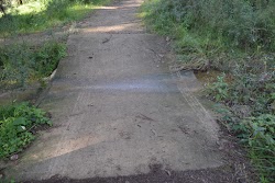
. This ford and track floods after heavy or prolonged rain and this area may also become boggy. The walk continues along the clear track for another 50m to come to a ‘Birds & black snakes’ information sign[40] and a seat

(on the left). From here this walk meanders gently uphill through the forest for about 120m to the ‘Rich Aboriginal area’ sign[41] (on the left). This walk continues to meanders gently uphill through the forest[42] for another 160m to come to a 3-way intersection[43] (beside the timber maze), marked by a ‘Take a stroll around’ sign[44] (on the right).
(0.8km) Maze Intersection → Rouse Hill main car park
70 m
2 mins
2m
0m
Easy track
Turn left: From the intersection, this walk follows the dirt/gravel track[45], directly away from the face of the ‘Take a stroll around’ sign[46] gently uphill towards the playground and picnic area. The track bends right and after 35m this walk comes to a 3-way intersection, marked with a large ‘Rouse Hill Regional Park[47] (on the left).
Continue straight: From the intersection, this walk heads directly away from the face of ‘Rouse Hill Regional Park’ sign[48] along the gravel track, keeping the playground on the right. After about 15m this walk comes to a ‘Welcome to Rouse Hill Regional Park’ sign[49]. From here this walk follows the concrete path for 15m, past the sheltered picnic area
Continue straight: From the intersection, this walk heads directly away from the face of ‘Rouse Hill Regional Park’ sign[48] along the gravel track, keeping the playground on the right. After about 15m this walk comes to a ‘Welcome to Rouse Hill Regional Park’ sign[49]. From here this walk follows the concrete path for 15m, past the sheltered picnic area
to come to the main Rouse Hill Regional Park car park[50].
Maps for the Second Ponds Creek walk walk
You can download the PDF for this walk to print a map.
These maps below cover the walk and the wider area around the walk, they are worth carrying for safety reasons.
| Riverstone | 1:25 000 Map Series | 90301S RIVERSTONE | NSW-90301S |
| Penrith | 1:100 000 Map Series | 9030 PENRITH | 9030 |
Cross sectional view of the Second Ponds Creek walk bushwalking track
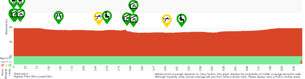
Analysis and summary of the altitude variation on the Second Ponds Creek walk
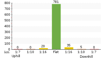
Accessibility summary information for the Second Ponds Creek walk
Parking: There are 0 designated accessible parking areas on this walk.
Toilets: There are 0 designated accessible toilets on this walk.
Seats: There are 5 places to sit on this walk.
They are on average 130m apart, with a maximum gap of 220m.
Hazards: There are 2 specific noteable accessability related hazards on this walk.
Trip Hazard Concrete creek ford. The ford is 2.3m wide 3.3m long and has a gradient in and out of 2:12. Found about 250m into the walk.
Trip Hazard Concrete creek ford. The ford is 2.4m wide 2.9m long and has a gradient in and out of 2:12. Found about 460m into the walk.
Accessibility Details

Found 0m into this walk
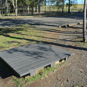
Found 0m into this walk
Found 0m into this walk
Found 10m into this walk
Found 20m into this walk


Found 340m into this walk

Found 360m into this walk

Found 360m into this walk

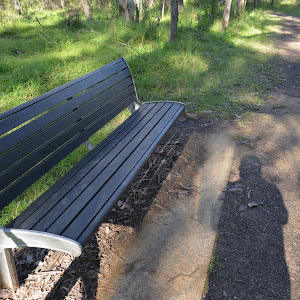
Overview of this walks grade – based on the AS 2156.1 – 2001
Under this standard, a walk is graded based on the most difficult section of the walk.
| Length | 865 m | ||
| Time | 20 mins | ||
| . | |||
| Grade 3/6 Moderate track |
AS 2156.1 | Gradient | Gentle hills with occasional steps (2/6) |
| Quality of track | Clear and well formed track or trail (2/6) | ||
| Signs | Directional signs along the way (3/6) | ||
| Experience Required | No experience required (1/6) | ||
| Weather | Storms may impact on navigation and safety (3/6) | ||
| Infrastructure | Generally useful facilities (such as fenced cliffs and seats) (1/6) |
Some more details of this walks Grading
Here is a bit more details explaining grading looking at sections of the walk
Gradient
Around 800m of this walk has gentle hills with occasional steps, whilst the remaining 65m is flat with no steps.
Quality of track
Around 800m of this walk follows a clear and well formed track or trail, whilst the remaining 65m follows a smooth and hardened path.
Signs
Around 730m of this walk has directional signs at most intersection, whilst the remaining 140m is clearly signposted.
Experience Required
This whole walk, 870m requires no previous bushwalking experience.
weather
Around 460m of this walk is affected by storms that may impact your navigation and safety, whilst the remaining 410m is not usually affected by severe weather events (that would unexpectedly impact safety and navigation).
Infrastructure
This whole walk, 870m is close to useful facilities (such as fenced cliffs and seats).
Similar walks
A list of walks that share part of the track with the Second Ponds Creek walk walk.
1.5 km Circuit
45 mins
Moderate track
Other Nearby walks
A list of walks that start near the Second Ponds Creek walk walk.
1.8 km Return
45 mins
Easy track
499 m One way
15 mins
Easy track
12.9 km One way
5 hrs 30 mins
Hard track
12.6 km One way
5 hrs 30 mins
Hard track
1.4 km Return
30 mins
Moderate track
515 m One way
15 mins
Moderate track
2.2 km One way
1 Hr
Moderate track
5.1 km Circuit
2 hrs
Hard track
9 km One way
3 hrs 45 mins
Hard track
4.1 km One way
1 hr 45 mins
Moderate track
4.4 km One way
1 hr 45 mins
Moderate track
439 m Circuit
15 mins
Moderate track
Plan your trip to and from the walk here
The Second Ponds Creek walk walk starts and ends at the Rouse Hill main car park (gps: -33.680471, 150.91068)
Your main transport option to Rouse Hill main car park is by;
![]() Car. There is free parking available.
Car. There is free parking available.
(get details)
Short URL = http://wild.tl/spcw
Gallery images
There are other downloads I am still working on.
You will probably need to login to access these — still all free.
* KML (google earth file)
* GPX (GPS file)
Special Maps/ brochures
* A3 topo maps
* PDF with Lands Topo map base
* PDF with arial image (and map overlay)
I wanted to get the main site live first, this extra stuff will come in time.
Happy walking
Matt 🙂
George Phillips Lookout walk
And Walk
George Phillips Lookout walk

30 mins
588 m Return
18 m
Very easy
On this short and easy walk, you will explore two lookouts with stunning views down the Grose Valley. Starting from the car park, you really should make the short side trip through the stone arch to Govetts Leap Lookout. The main walk follows the well-formed footpath through the bush up to the less visited George Phillips Lookout. There are a pleasant stone shelter and picnic tables here. Around the car park are plenty of picnic facilities and a toilet block. A great walk giving you a sense of the scale of the breathtaking Grose Valley.


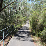

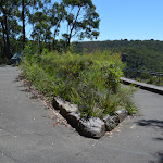
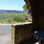
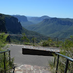
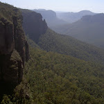

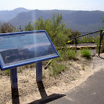


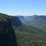
(0km) Govetts Leap Lookout Picnic Area → Govetts Leap Lookout
40 m
1 mins
0m
-7m
Very easy
Govetts Leap Lookout

Govetts Leap Lookout is named after the first European man to have enjoyed this view, William Govett, as an assistant surveyor in June 1831. Govetts Leap Lookout offers wonderful views over the Grose Valley and the spectacular Bridal Falls. The word `leap` is an old Scottish word meaning waterfall. The lookout is easily accessed from the car park[9], there are also toilets[10]

and picnic shelters[11]

nearby.
(0km) Govetts Leap Lookout Picnic Area → George Phillips Lookout
290 m
6 mins
11m
-7m
Very easy
Turn right: From the large stone shelter[12]

at the edge of the turning circle (and car park)[13] at the end of Govetts Leap Rd, this walk heads for about 60m across the dirt/gravel[14] car park, away from the main cliff views, keeping the road to the left. The walk then heads between the timber bollards[15]

, to follow the ‘The Fairfax Heritage Trail’ asphalt path[16] and continues gently uphill for 180m to where path bends sharply left, then right. Here the walk continues along the path for another 25m to the signposted[17] ‘George Phillips Lookout’[18] (on your right).
George Phillips Lookout
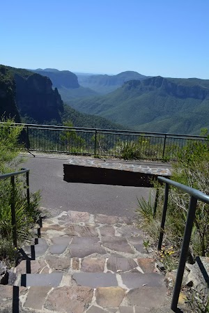
George Phillips Lookout, Blue Mountains National Park, provides stunning views east into the Grose Valley. The lookout offers views to Pulpit Rock, the horseshoe-shaped gorge and over the deep, green gorges of the Grose Valley to Mount Banks. The lookout is fenced and has a wheelchair accessible ramp. There are a series of picnic tables including a stone shelter

just behind the lookout.
Maps for the George Phillips Lookout walk walk
You can download the PDF for this walk to print a map.
These maps below cover the walk and the wider area around the walk, they are worth carrying for safety reasons.
| Katoomba | 1:25 000 Map Series | 89301S KATOOMBA | NSW-89301S |
| Katoomba | 1:100 000 Map Series | 8930 KATOOMBA | 8930 |
Cross sectional view of the George Phillips Lookout walk bushwalking track
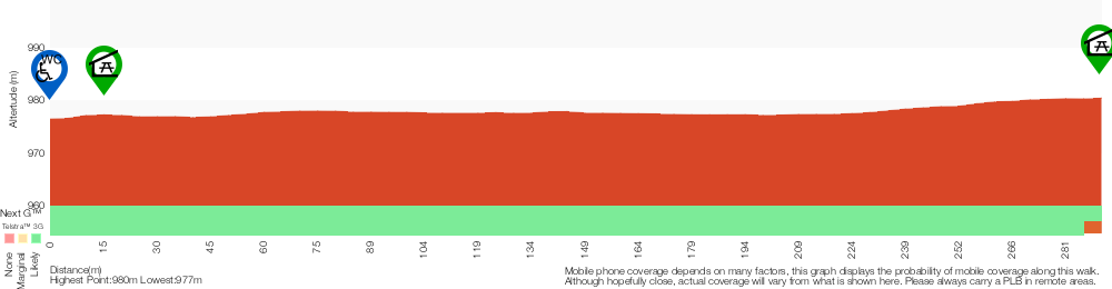
Analysis and summary of the altitude variation on the George Phillips Lookout walk
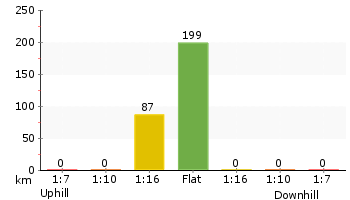
Accessibility summary information for the George Phillips Lookout walk
Parking: There are 0 designated accessible parking areas on this walk.
Toilets: There are 0 designated accessible toilets on this walk.
Seats: There are 1 places to sit on this walk.
Hazards: There are 2 specific noteable accessability related hazards on this walk.
Wheelchair Rough This walk leads through a gravel carpark for about 60m. The surface in unevean and erroded in places. The gravel is mostly compressed but the surface may soften after prolonged rain. Found about 30m into the walk.
Trip Hazard A 5 to 10cm step between carpark and track. Access is between bollards that are 110cm apart. Found about 70m into the walk.
Accessibility Details

Found 0m into this walk
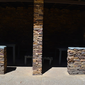
Found 10m into this walk
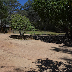
Found 30m into this walk
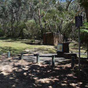
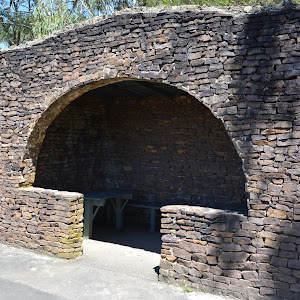
Found 290m into this walk
Overview of this walks grade – based on the AS 2156.1 – 2001
Under this standard, a walk is graded based on the most difficult section of the walk.
| Length | 588 m | ||
| Time | 30 mins | ||
| . | |||
| Grade 1/6 Very easy |
AS 2156.1 | Gradient | Flat, no steps (1/6) |
| Quality of track | Smooth and hardened path (1/6) | ||
| Signs | Clearly signposted (1/6) | ||
| Experience Required | No experience required (1/6) | ||
| Weather | Weather generally has little impact on safety (1/6) | ||
| Infrastructure | Generally useful facilities (such as fenced cliffs and seats) (1/6) |
Some more details of this walks Grading
Here is a bit more details explaining grading looking at sections of the walk
Gradient
This whole walk, 290m is flat with no steps.
Quality of track
This whole walk, 290m follows a smooth and hardened path.
Signs
This whole walk, 290m is clearly signposted.
Experience Required
This whole walk, 290m requires no previous bushwalking experience.
weather
This whole walk, 290m is not usually affected by severe weather events (that would unexpectedly impact safety and navigation).
Infrastructure
This whole walk, 290m is close to useful facilities (such as fenced cliffs and seats).
Similar walks
A list of walks that share part of the track with the George Phillips Lookout walk walk.
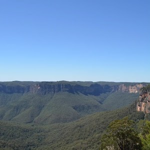
1.9 km One way
45 mins
Very easy
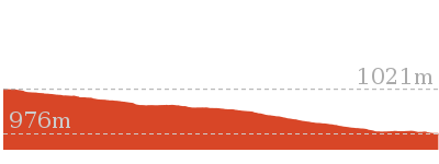
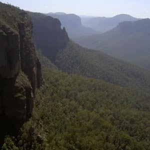
2.4 km Circuit
1 Hr
Very easy
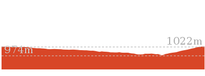
Other Nearby walks
A list of walks that start near the George Phillips Lookout walk walk.
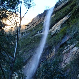
1.2 km Return
1 hr 45 mins
Hard track
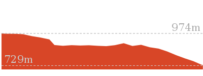
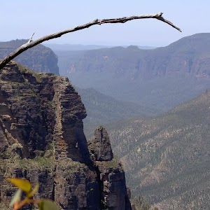
3.8 km One way
2 hrs 30 mins
Hard track
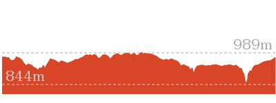
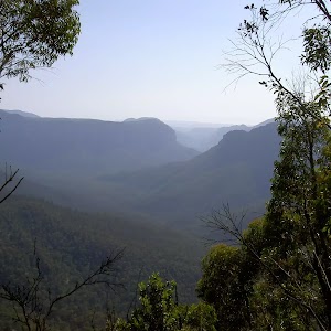
3.2 km One way
1 hr 45 mins
Hard track
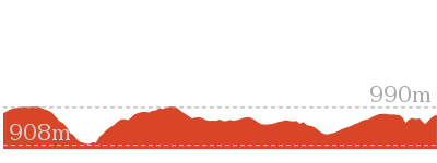
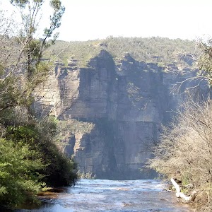
1.4 km Return
1 Hr
Hard track
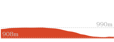
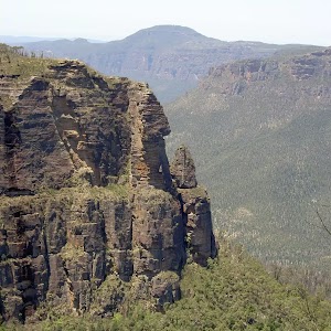
13.6 km Circuit
8 hrs
Hard track
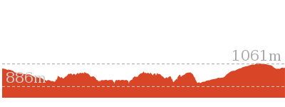
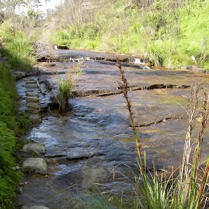
2.5 km Return
1 Hr
Hard track
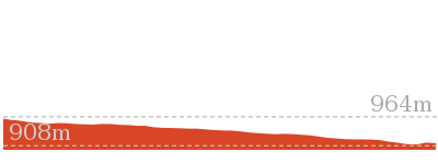
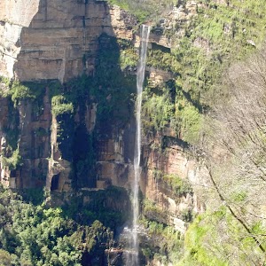
4.2 km One way
2 hrs 30 mins
Hard track
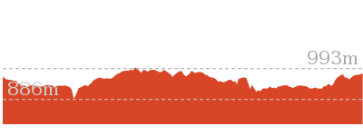
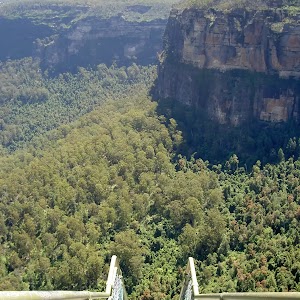
816 m Return
45 mins
Hard track
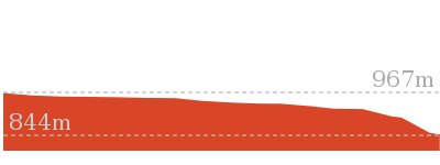
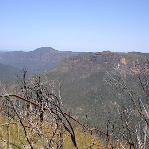
748 m Return
30 mins
Moderate track
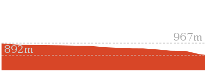
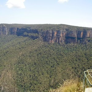
630 m Return
30 mins
Moderate track
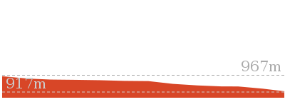
6.6 km One way
4 hrs 15 mins
Hard track
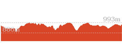
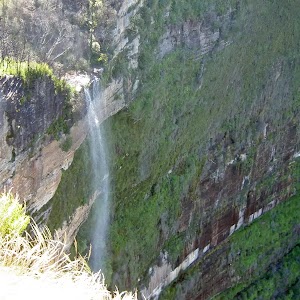
8.7 km Circuit
3 hrs 30 mins
Hard track
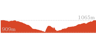
Plan your trip to and from the walk here
The George Phillips Lookout walk walk starts and ends at the Govetts Leap Lookout Picnic Area (gps: -33.628268, 150.31109)
Your main transport option to Govetts Leap Lookout Picnic Area is by;
![]() Car. There is free parking available.
Car. There is free parking available.
(get details)
Short URL = http://wild.tl/gplw
Gallery images
There are other downloads I am still working on.
You will probably need to login to access these — still all free.
* KML (google earth file)
* GPX (GPS file)
Special Maps/ brochures
* A3 topo maps
* PDF with Lands Topo map base
* PDF with arial image (and map overlay)
I wanted to get the main site live first, this extra stuff will come in time.
Happy walking
Matt 🙂
Mangrove Boardwalk to Schoolmasters House

30 mins
1.2 km Return
4 m
Very easy
Wander among the mangroves to step back in time to explore the old Schoolmaster’s House that was part of a once vibrant community in the area. Following devastating floods in 1955, the people moved from the area with the area still being leased as farmland. Now, these wetlands are protected as part of the national park ensuring the survival of the endangered ecological community of saltmarsh and all the fish, birds and other animals that rely on them for survival. Bring a picnic lunch and settle under a tree or bring binoculars and a bird guide. Take your time to enjoy all this area has on offer.


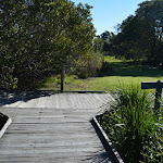


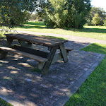
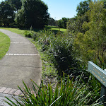


(0km) Mangrove Boardwalk car park → Boardwalk seating area
350 m
5 mins
0m
0m
Very easy
From the Mangrove Boardwalk car park

[1] on Millams Rd Kooragang, (with the large ‘Welcome to Kooragang Wetlands’ sign[2]) this walk follows the ‘Mangrove Boardwalk’ arrow[3] along the timber boardwalk directly away from the road. This walk gently meanders along the boardwalk for about 80m to cross a bridge with (90cm high) hand railings[4], to come to a seat

about 50m later. This walk then continues for the next 160m, passing a few information signs[5][6][7] to find another seat

. The walk continues along the boardwalk through the open wetlands for another 60m to come to a third seat

(on the left).
Mangroves

Mangroves are a type of resistant, salt tolerant and pretty cool tree. They are are a type of halophyte, a plant that grows in salty water. They are perfectly adapted for life in harsh coastal conditions and salt marshes like this one. The plants contain systems to manage the salt levels and root system to anchor in different areas from deep mud to rocky coastlines. The roots also have aerial shoots to help deal with the particular low oxygen levels of mud. The mangroves are great and environmentaly critical to the survival of many animals like crabs and birds.
(0.35km) Boardwalk seating area → Mangrove Boardwalk int.
190 m
3 mins
2m
-2m
Very easy
(0.54km) Mangrove Boardwalk int. → Cobbans Track int.
160 m
2 mins
1m
-1m
Very easy
Turn right: From the intersection, this walk follows ‘Cobbans Creek’ arrow sign[14] along the timber boardwalk keeping the open area to the left. After about 40m the boardwalk ends and this walk heads along an asphalt path[15], for about 10m to a seat

and the ‘Sue’s Garden’ sign[16] (both on the left). From here this walk continues along the asphalt path for about 110m, passing two more seats


and a picnic table

(on the left) to cross a short timber bridge and come to the Cobbans Track T-intersection[17], marked by the ‘Cobbans Creek’ sign[18]. At the end of this side trip, retrace your steps back to the main walk then Turn right.
(0.54km) Mangrove Boardwalk int. → Schoolmasters House
60 m
1 mins
0m
0m
Very easy
Veer left: From the intersection, this walk follows ‘schoolmasters house’ sign[19] gently uphill along the concrete path[20]. After about 20m the path leads past a picnic table

(on the left) and continues for about 30m to come to the front of the ‘School Masters House’[21] (on the right). Access to the old school house is either via smaller steps[22] or around the far side by heading through the car park where there are a few picnic tables

.
Schoolmasters House
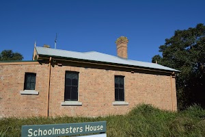
The schoolmaster’s house building is now used as the Kooragang Wetlands Information Centre. The building is open to the public (phone 02-4964 9308), with some interesting displays. In 1955 there were over 50 families and this school in the area, when the island was devastated by a massive flood. Following the flood, the area then was taken under state control and was leased for grazing. The school opened in 1873 and closed in 1968.
There are two main entrances. The back entrance has 3 14cm steps to get inside[26]. More info.
There are two main entrances. The back entrance has 3 14cm steps to get inside[26]. More info.
Maps for the Mangrove Boardwalk to Schoolmasters House walk
You can download the PDF for this walk to print a map.
These maps below cover the walk and the wider area around the walk, they are worth carrying for safety reasons.
| Beresfield | 1:25 000 Map Series | 92323N BERESFIELD | NSW-92323N |
| Newcastle | 1:100 000 Map Series | 9232 NEWCASTLE | 9232 |
Cross sectional view of the Mangrove Boardwalk to Schoolmasters House bushwalking track
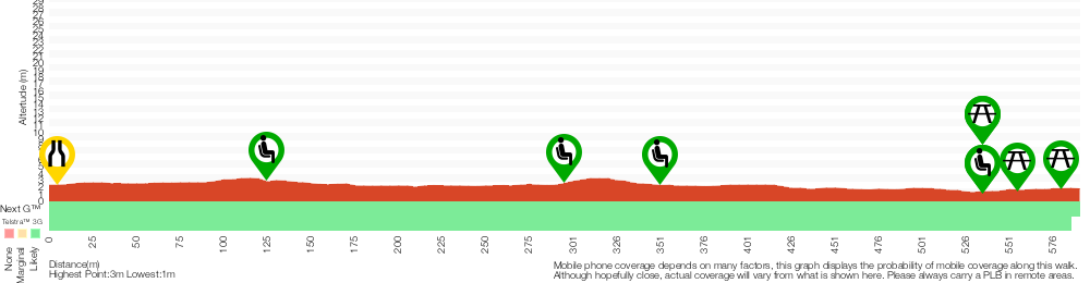
Analysis and summary of the altitude variation on the Mangrove Boardwalk to Schoolmasters House
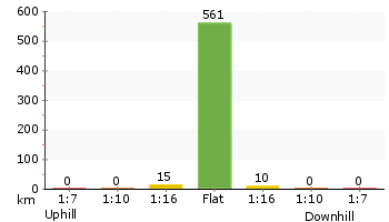
Accessibility summary information for the Mangrove Boardwalk to Schoolmasters House
Parking: There are 0 designated accessible parking areas on this walk.
Toilets: There are 0 designated accessible toilets on this walk.
Seats: There are 5 places to sit on this walk.
They are on average 150m apart, with a maximum gap of 210m.
Hazards: There are 0 specific noteable accessability related hazards on this walk.
Toilets: There are 0 designated accessible toilets on this walk.
Seats: There are 5 places to sit on this walk.
They are on average 150m apart, with a maximum gap of 210m.
Hazards: There are 0 specific noteable accessability related hazards on this walk.
Accessibility Details


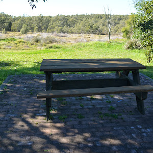
Found 540m into this walk

Found 560m into this walk

Found 580m into this walk
Overview of this walks grade – based on the AS 2156.1 – 2001
Under this standard, a walk is graded based on the most difficult section of the walk.
| Length | 1.2 km | ||
| Time | 30 mins | ||
| . | |||
| Grade 1/6 Very easy |
AS 2156.1 | Gradient | Flat, no steps (1/6) |
| Quality of track | Smooth and hardened path (1/6) | ||
| Signs | Clearly signposted (1/6) | ||
| Experience Required | No experience required (1/6) | ||
| Weather | Weather generally has little impact on safety (1/6) | ||
| Infrastructure | Generally useful facilities (such as fenced cliffs and seats) (1/6) |
Some more details of this walks Grading
Here is a bit more details explaining grading looking at sections of the walk
Gradient
This whole walk, 590m is flat with no steps.
Quality of track
This whole walk, 590m follows a smooth and hardened path.
Signs
This whole walk, 590m is clearly signposted.
Experience Required
This whole walk, 590m requires no previous bushwalking experience.
weather
This whole walk, 590m is not usually affected by severe weather events (that would unexpectedly impact safety and navigation).
Infrastructure
This whole walk, 590m is close to useful facilities (such as fenced cliffs and seats).
Similar walks
A list of walks that share part of the track with the Mangrove Boardwalk to Schoolmasters House walk.
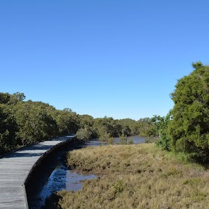
945 m One way
30 mins
Easy track

Other Nearby walks
A list of walks that start near the Mangrove Boardwalk to Schoolmasters House walk.
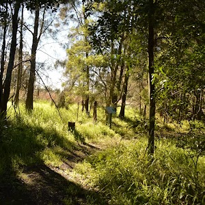
2 km One way
45 mins
Moderate track
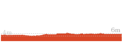
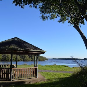
1.9 km One way
45 mins
Easy track
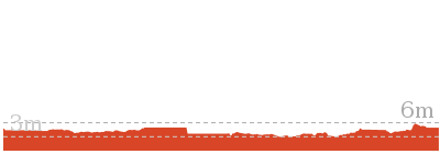
1.3 km Return
30 mins
Easy track
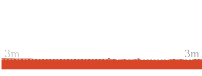

2.5 km Return
45 mins
Easy track
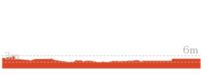
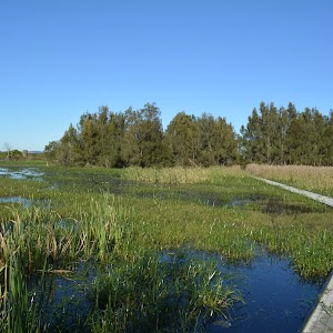
3.9 km Circuit
1 hr 15 mins
Moderate track
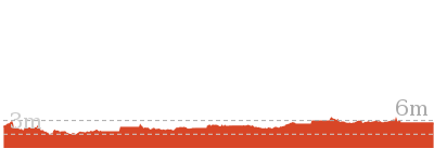
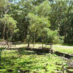
2.7 km Circuit
1 Hr
Moderate track
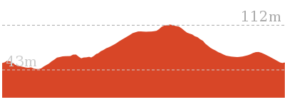
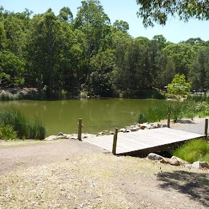
6.5 km Circuit
2 hrs 30 mins
Moderate track

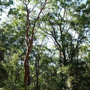
2.8 km Circuit
1 hr 15 mins
Moderate track

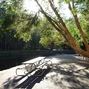
2.9 km Circuit
1 hr 15 mins
Moderate track
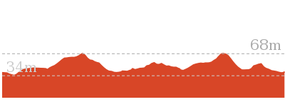
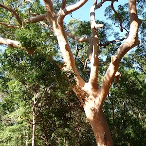
6 km Circuit
2 hrs 30 mins
Moderate track
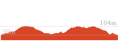
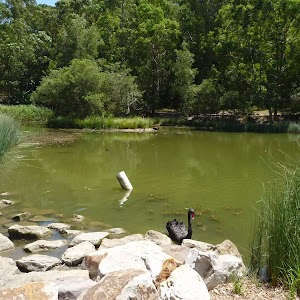
731 m Circuit
30 mins
Very easy
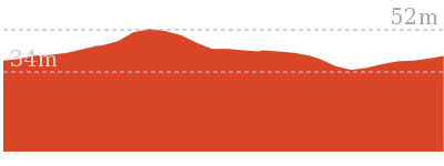
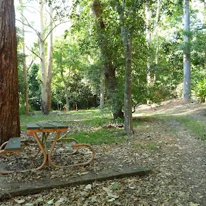
1.9 km Circuit
1 Hr
Moderate track
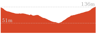
Plan your trip to and from the walk here
The Mangrove Boardwalk to Schoolmasters House walk starts and ends at the Mangrove Boardwalk car park (gps: -32.844726, 151.69741)
Your main transport option to Mangrove Boardwalk car park is by;
![]() Car. There is free parking available.
Car. There is free parking available.
(get details)
Short URL = http://wild.tl/mbtsh
Gallery images
There are other downloads I am still working on.
You will probably need to login to access these — still all free.
* KML (google earth file)
* GPX (GPS file)
Special Maps/ brochures
* A3 topo maps
* PDF with Lands Topo map base
* PDF with arial image (and map overlay)
I wanted to get the main site live first, this extra stuff will come in time.
Happy walking
Matt 🙂
Comments