Heaton Gap to Teralba station


Watagan Forest Motel
(0km) Watagan Forest Motel → Int of Gap Road and GNW track
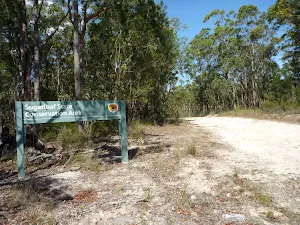
Turn left: From the intersection[15], this walk follows the GNW arrow post, gently uphill along the dirt road[16], initially passing the 'Sugarloaf State Conservation Area' sign[17] on your right. The walk continues for about 700m (with one steep uphill section[18]), until leading down to an intersection[19] with a track and GNW arrow marker, and a couple of timber fence posts (on the left).
(1km) Int of Gap Road AND GNW → Int of GNW AND Brunkerville trail
Continue straight: From the intersection, this walk follows the grassy trail east, gently uphill[31]. The trail leads up along the ridge for about 300m to where the trail widens and become much clearer[32]. The walk continues along this trail for just over 200m to come to an intersection with a dirt road[33], where a there is a 'The Great North Walk' sign[34] on the left.
(3km) Int of GNW track and Brunkerville trail → Int of Brunkerville and Sugarloaf Range trail
(4km) Int of Brunkerville and Sugarloaf Range trail → Int of Sugarloaf Range and Wakefield Forest Roads
(5km) Int of Sugarloaf Range and Wakefield Forest Roads → Int of GNW track AND Aubs Ridge Road
Veer right: From the intersection[50], this walk follows the GNW arrow post moderately steeply down along the dirt road[51], following the ridge line east. After just shy of 500m, this walk comes to an intersection[52] with 'Aubs Ridge Road'[53] (on the right).
(6km) Int of GNW track and Aubs Ridge Road → Int of Archery Road and GNW track
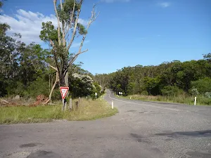
Veer left: From the intersection[60], this walk follows the GNW arrow post gently downhill along the wide dirt road[61], directly away from the face of the 'Sugarloaf State Conservation Area' sign[62]. The walk continues down the road for 230m, until coming to a wide intersection[63] with a number of trails, just past a 'Warning Mine Subsidence...' sign[64] (facing away from you).
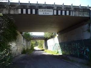
Continue straight: From the intersection[65], this walk follows the GNW arrow post gently downhill[66] along the wide dirt road, directly away from face of the 'Mine Subsidence' sign[67]. The road bends right (passing a private driveway[68]) then leads under two Sydney/Newcastle Freeway bridges[69]. The road then leads gently uphill (ignoring side roads[70][71]) for about 350m to the top of the hill (just past the second power pole[72] and the 'Lake Macqurie Field Archers Inc' sign[73] to find an intersection, marked with a 'The Great North Walk' sign[74].
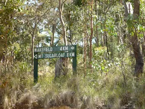
(8km) Int of Archery Road and the GNW track → Int of GNW track and Wakefield Road
(9km) Int of Great North Walk and Wakefield Road → Eddie Peterson Memorial Park
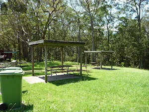
Eddie Peterson Memorial Park

(9km) Eddie Peterson Memorial Park → Int of Wakefield and Rhondda Roads
(11km) Int of Wakefield and Rhondda Roads → Teralba Station
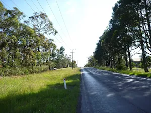
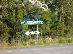
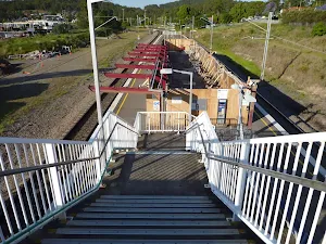
Turn left: From the intersection[103], this walk follows the GNW arrow post gently up along 'Railway Rd'[104]. The walk follows Railway Rd for just shy of 250m, to another GNW arrow marker[105] and turns right. Here the walk heads up the steps on the railway pedestrian bridge to find 'Teralba' railway station[106].
Maps for the Heaton Gap to Teralba station walk
You can download the PDF for this walk to print a map.
These maps below cover the walk and the wider area around the walk, they are worth carrying for safety reasons.
| Wallsend | 1:25 000 Map Series | 92323S WALLSEND | NSW-92323S |
| Quorrobolong | 1:25 000 Map Series | 91322S QUORROBOLONG | NSW-91322S |
| Cessnock | 1:50 000 Map Series | 91322 CESSNOCK | CW-91322 |
| Newcastle | 1:100 000 Map Series | 9232 NEWCASTLE | 9232 |
| Cessnock | 1:100 000 Map Series | 9132 CESSNOCK | 9132 |
Cross sectional view of the Heaton Gap to Teralba station bushwalking track
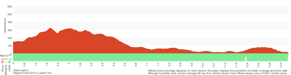
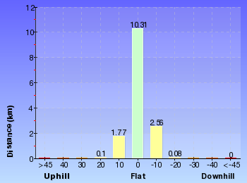
Analysis and summary of the altitude variation on the Heaton Gap to Teralba station
Overview of this walks grade – based on the AS 2156.1 – 2001
Under this standard, a walk is graded based on the most difficult section of the walk.
| Length | 14.8 km | ||
| Time | 6 hrs | ||
| . | |||
Grade 4/6 Hard track | AS 2156.1 | Gradient | Very steep (4/6) |
| Quality of track | Formed track, with some branches and other obstacles (3/6) | ||
| Signs | Directional signs along the way (3/6) | ||
| Experience Required | Some bushwalking experience recommended (3/6) | ||
| Weather | Weather generally has little impact on safety (1/6) | ||
| Infrastructure | Limited facilities (such as cliffs not fenced, significant creeks not bridged) (4/6) |
Some more details of this walks Grading
Here is a bit more details explaining grading looking at sections of the walk
Gradient
7km of this walk has gentle hills with occasional steps and another 3.2km has short steep hills. Whilst another 2.9km is flat with no steps and the remaining 2.2km is very steep.
Quality of track
9km of this walk follows a clear and well formed track or trail and another 3.6km follows a smooth and hardened path. The remaining (2.2km) follows a formed track, with some branches and other obstacles.
Signs
Around 8km of this walk has directional signs at most intersection, whilst the remaining 7km is clearly signposted.
Experience Required
Around 13km of this walk requires no previous bushwalking experience, whilst the remaining 2.2km requires some bushwalking experience.
weather
This whole walk, 15km is not usually affected by severe weather events (that would unexpectedly impact safety and navigation).
Infrastructure
8km of this walk is close to useful facilities (such as fenced cliffs and seats) and another 5km has limited facilities (such as not all cliffs fenced). The remaining (1.4km) has limited facilities (such as cliffs not fenced, significant creeks not bridged).
Other Nearby walks
A list of walks that start near the Heaton Gap to Teralba station walk.
Heaton Lookout to Heaton Gap
4.3 km One way, 2 hrs
Hard track
Hunter Lookout and Great North Walk loop
5.6 km Circuit, 2 hrs 30 mins

Hard track
Hunter Lookout to Glen road loop
2.5 km Circuit, 1 Hr

Hard track
Watagan Forestry HQ campsite to Heaton Gap
12.5 km One way, 6 hrs

Hard track
Watagan Headquarters to Heaton Lookout
8.1 km One way, 4 hrs

Hard track
Teralba to Charlestown Park track head
13.3 km One way, 4 hrs 30 mins

Moderate track
Teralba to Newcastle via Glenrock Scout Camp
25.7 km One way, 2 Days
Hard track
Boarding House Dam Circuit
718 m Circuit, 30 mins
Moderate track
Moss Wall Walk
516 m Return, 15 mins
Moderate track
Gap Creek Falls Walk
1.5 km Return, 1 Hr
Moderate track
Gap Creek Rainforest Walk
1.7 km Return, 1 Hr

Hard track
Georges Road Rest Area to 125r Lookout
4.4 km Return, 3 hrs 30 mins
Moderate track
Plan your trip to and from the walk here
The Heaton Gap to Teralba station walk starts at the Watagan Forest Motel (gps: -32.965273, 151.47937)
The Heaton Gap to Teralba station ends at the Teralba Station (gps: -32.962353, 151.60378)
Weather Forecast
This walk starts in the Hunter weather district.
Current Alerts
Park Information
Awaba State Forest
A large parcel of land west of the northern end of lake Macquarie, Awaba state forest lines the side of part of the Sydney - newcastle freeway. The park is home to mostly native forest
Comments
Short URL: http://wild.tl/hgtts